IMAGES TAKEN NEAR TO
Sullivan Road, LONDON, SE11 4UH
Introduction
This page details the photographs taken nearby to Sullivan Road, SE11 4UH by members of the Geograph project.
The Geograph project started in 2005 with the aim of publishing, organising and preserving representative images for every square kilometre of Great Britain, Ireland and the Isle of Man.

There are currently over 7.5m images from over14,400 individuals and you can help contribute to the project by visiting https://www.geograph.org.uk
Image Map
Images are licensed for reuse under creativecommons.org/licenses/by-sa/2.0
Notes
- Clicking on the map will re-center to the selected point.
- The higher the marker number, the further away the image location is from the centre of the postcode.
Image Listing (281 Images Found)
Images are licensed for reuse under creativecommons.org/licenses/by-sa/2.0
Image
Details
Distance
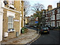
1
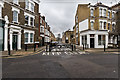
Sullivan Road barrier
A barrier across the end of Sullivan Road at the junction with Brook Street.
Image: © David P Howard
Taken: 24 Jan 2016
0.03 miles
2
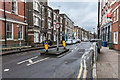
Width restriction on Brook Drive
A centre island and high kerbs have been installed to reduce the width down to 2.2 metres, 7 feet 6 inches, to stop large vehicles using this road.
Image: © David P Howard
Taken: 24 Jan 2016
0.06 miles
3
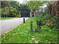
Ice Age Tree Trail No. 28 - Box (Buxus sempervirens)
The Ice Age Tree Trail in Geraldine Mary Harmsworth Park has specimens of trees native to Britain. Box was the 28th tree to have colonised Britain, arriving about 8000 years ago. It is heavier than water and twice as hard as oak. Unlike other timber, it is sold by weight rather than size. It is long lived and slow growing, hence the small size of this specimen. It reaches a maximum height of 9 metres.
Image: © Rod Allday
Taken: 17 Oct 2010
0.08 miles
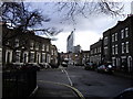
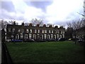
4
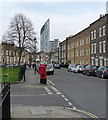
Walcot Square
An attractive spot laid out in 1837-39. All Grade II listed.
Beyond are the Strata building and the Draper Estate at Elephant and Castle (Image]).
Image: © Stephen Richards
Taken: 12 Mar 2011
0.08 miles
6
St Mary's Gardens. Lambeth
St Mary's Gardens were once part of the Walcot estate but the charity only owns a few of the houses now as they sold some off in the 1980's and 90's.
Image: © PAUL FARMER
Taken: 27 Dec 2009
0.08 miles
7
Bishop's Terrace, Lambeth
This area was part of the Walcot Estate, 17 acres of land donated to the poor of Lambeth by Edmund Walcott (note the different spelling) in 1667. The houses immediately ahead were built in the 1830s and are in St Mary's Gardens. The area is a quiet retreat from the bustle of Kennington Road, just yards away.
Image: © Stephen McKay
Taken: 10 Jul 2007
0.10 miles
8
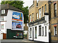
Bishop's Terrace, Lambeth
Showing the rear of The Ship public house; the front faces on to Kennington Road.
Image: © Stephen McKay
Taken: 10 Jul 2007
0.11 miles
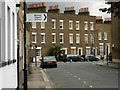
9
Walcot Square Lambeth
Walcot Square was laid out and the houses erected in 1837–39, the houses are terrace type in yellow stock brick with stucco surrounds to the entrances and a plain coping above the parapets.
Image: © PAUL FARMER
Taken: 27 Dec 2009
0.11 miles
10

25-28 West Square
The south-east corner of this elegant Georgian enclave tucked away a stone's throw from the Elephant. This plain group, built c1800-10, relies entirely on its proportions for effect. Grade II listed.
Image: © Stephen Richards
Taken: 6 May 2013
0.11 miles