IMAGES TAKEN NEAR TO
Knights Walk, LONDON, SE11 4PA
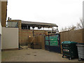
Introduction
This page details the photographs taken nearby to Knights Walk, SE11 4PA by members of the Geograph project.
The Geograph project started in 2005 with the aim of publishing, organising and preserving representative images for every square kilometre of Great Britain, Ireland and the Isle of Man.

There are currently over 7.5m images from over14,400 individuals and you can help contribute to the project by visiting https://www.geograph.org.uk
Image Map
Images are licensed for reuse under creativecommons.org/licenses/by-sa/2.0
Notes
- Clicking on the map will re-center to the selected point.
- The higher the marker number, the further away the image location is from the centre of the postcode.
Image Listing (149 Images Found)
Images are licensed for reuse under creativecommons.org/licenses/by-sa/2.0
Image
Details
Distance
1
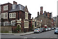
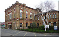
Renfrew Road
The former Tudor-Gothic Magistrates' Court (1869, by Thomas Charles Sorby) is now a Buddhist centre. Beyond, another public building, a fire station complete with watchtower (1868/1896, by Edward Cresy/Robert Pearsall and the LCC) has found a new life, as flats. Both Grade II listed.
Image: © Stephen Richards
Taken: 12 Mar 2011
0.04 miles
2
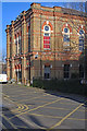
Cinema Museum, Kennington
The privately owned but under-threat Cinema Museum is housed in the former Lambeth Workhouse (later Infirmary). For a brief history of the site see this http://landmark.lambeth.gov.uk/display_page.asp?section=landmark&id=8041.
Image: © Jim Osley
Taken: 17 Jan 2018
0.05 miles
3
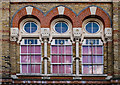
Tri-partite window, Cinema Museum, Kennington
Fuller view of the building at this Image]
Image: © Jim Osley
Taken: 31 Jan 2018
0.05 miles
4
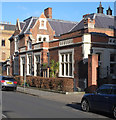
Former Lambeth Magistrates Court building, Renfrew Road
Grade II listed building from 1869. Architect: Thomas Charles Sorby. Description at this https://historicengland.org.uk/listing/the-list/list-entry/1251239. Currently a Buddhist Centre and cafe.
Image: © Jim Osley
Taken: 17 Jan 2018
0.05 miles
5
Former Lambeth Hospital, Brook Drive
In fact built as the central block of Lambeth Workhouse in 1870-71. Given its function, a surprisingly flamboyant affair of yellow stock brick with red brick, stone and terracotta dressings. Grade II listed.
Much of the workhouse has since gone, what remained was subsumed into Lambeth Infirmary, and is now being converted into flats.
Image: © Stephen Richards
Taken: 12 Mar 2011
0.07 miles
6
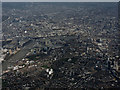
Lambeth from the air
The Houses of Parliament, London Eye, Waterloo Station and the Imperial War Museum are all visible in this view from a Heathrow bound flight from Prague.
Image: © Thomas Nugent
Taken: 1 Apr 2015
0.09 miles
7
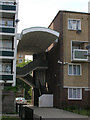
Stairwell at Falstaff Court from Kenningtom Park Road
Image: © Robin Sones
Taken: 23 Jun 2006
0.10 miles
8
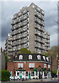
Cotton Gardens Estate, Kennington Lane
The Little Apple pub has three formidable bouncers which display the fondness for jagged profiles to be found in Lambeth Architects' Department in the late 1960s (see also e.g. Image]). Their names are Ebenezer House, Fairford House and Hurley House.
Image: © Stephen Richards
Taken: 21 Apr 2012
0.10 miles
9
Covered washing line
I am unsure whether the building shown here - with washing hung beneath its roof - is part of the original workhouse/hospital - see Image - or part of the new development but using period architectural ironwork.
Image: © Stephen Craven
Taken: 10 Mar 2012
0.10 miles
10
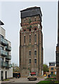
Former water tower, Renfrew Road
Built to serve Lambeth Workhouse in 1877 by Fowler & Hill in a Venetian Gothic style with mighty buttresses and crowned by a large metal tank. The surrounding area was in the process of being converted into flats, and it looked as if the tower was at least being attended to, but it is currently on English Heritage's Heritage at Risk Register. A challenging building for which to find a new use. Grade II listed.
Fellow Geographer, Terry Robinson, tells me that the conversion of this tower into a nine-storey private residence was recently (October 2012) related in an episode of Channel 4's Grand Designs.
Image: © Stephen Richards
Taken: 2 Apr 2011
0.11 miles