IMAGES TAKEN NEAR TO
Wincott Street, LONDON, SE11 4NR
Introduction
This page details the photographs taken nearby to Wincott Street, SE11 4NR by members of the Geograph project.
The Geograph project started in 2005 with the aim of publishing, organising and preserving representative images for every square kilometre of Great Britain, Ireland and the Isle of Man.

There are currently over 7.5m images from over14,400 individuals and you can help contribute to the project by visiting https://www.geograph.org.uk
Image Map
Images are licensed for reuse under creativecommons.org/licenses/by-sa/2.0
Notes
- Clicking on the map will re-center to the selected point.
- The higher the marker number, the further away the image location is from the centre of the postcode.
Image Listing (109 Images Found)
Images are licensed for reuse under creativecommons.org/licenses/by-sa/2.0
Image
Details
Distance
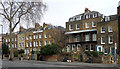
1
St Mary's Gardens. Lambeth
St Mary's Gardens were once part of the Walcot estate but the charity only owns a few of the houses now as they sold some off in the 1980's and 90's.
Image: © PAUL FARMER
Taken: 27 Dec 2009
0.09 miles
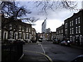
2
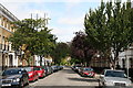
177-193 Kennington Road
Early-C19th houses, not as uniform a terrace as much of the rest of the road, but the flow still not disrupted by modern intrusions. The pair on the right share a verandah. All Grade II listed.
Image: © Stephen Richards
Taken: 12 Mar 2011
0.10 miles
3
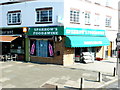
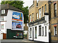
Sparrows Food and Wine Shop
Sparrows Food and wine shop is at 7 Wincott Parade, Kennington Road, Lambeth
London, SE11 6SR and it sells beers , wines spirits and groceries.
Image: © Nigel Mykura
Taken: 5 Mar 2013
0.11 miles
4
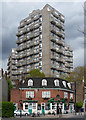
Cotton Gardens Estate, Kennington Lane
The Little Apple pub has three formidable bouncers which display the fondness for jagged profiles to be found in Lambeth Architects' Department in the late 1960s (see also e.g. Image]). Their names are Ebenezer House, Fairford House and Hurley House.
Image: © Stephen Richards
Taken: 21 Apr 2012
0.11 miles
5
Bishop's Terrace, Lambeth
Showing the rear of The Ship public house; the front faces on to Kennington Road.
Image: © Stephen McKay
Taken: 10 Jul 2007
0.11 miles
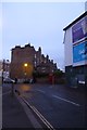
6
Kennington: Chester Way
Looking northwest.
Image: © Dr Neil Clifton
Taken: 23 Jun 2012
0.12 miles
7
Bishop's Terrace
Looking along Bishop's Terrance from Kennington Road.
Image: © DS Pugh
Taken: 11 Dec 2015
0.12 miles
8
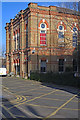
Cinema Museum, Kennington
The privately owned but under-threat Cinema Museum is housed in the former Lambeth Workhouse (later Infirmary). For a brief history of the site see this http://landmark.lambeth.gov.uk/display_page.asp?section=landmark&id=8041.
Image: © Jim Osley
Taken: 17 Jan 2018
0.12 miles
9
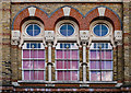
Tri-partite window, Cinema Museum, Kennington
Fuller view of the building at this Image]
Image: © Jim Osley
Taken: 31 Jan 2018
0.12 miles
10
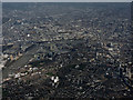
Lambeth from the air
The Houses of Parliament, London Eye, Waterloo Station and the Imperial War Museum are all visible in this view from a Heathrow bound flight from Prague.
Image: © Thomas Nugent
Taken: 1 Apr 2015
0.13 miles