IMAGES TAKEN NEAR TO
George Mathers Road, LONDON, SE11 4BS
Introduction
This page details the photographs taken nearby to George Mathers Road, SE11 4BS by members of the Geograph project.
The Geograph project started in 2005 with the aim of publishing, organising and preserving representative images for every square kilometre of Great Britain, Ireland and the Isle of Man.

There are currently over 7.5m images from over14,400 individuals and you can help contribute to the project by visiting https://www.geograph.org.uk
Image Map (Loading...)


Getting Data...Please wait
Leaflet Map data © OpenStreetMap
Images are licensed for reuse under creativecommons.org/licenses/by-sa/2.0
Notes
- Clicking on the map will re-center to the selected point.
- The higher the marker number, the further away the image location is from the centre of the postcode.
Image Listing (254 Images Found)
Images are licensed for reuse under creativecommons.org/licenses/by-sa/2.0
Image
Details
Distance
1
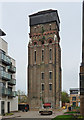
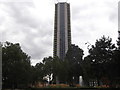
Former water tower, Renfrew Road
Built to serve Lambeth Workhouse in 1877 by Fowler & Hill in a Venetian Gothic style with mighty buttresses and crowned by a large metal tank. The surrounding area was in the process of being converted into flats, and it looked as if the tower was at least being attended to, but it is currently on English Heritage's Heritage at Risk Register. A challenging building for which to find a new use. Grade II listed.
Fellow Geographer, Terry Robinson, tells me that the conversion of this tower into a nine-storey private residence was recently (October 2012) related in an episode of Channel 4's Grand Designs.
Image: © Stephen Richards
Taken: 2 Apr 2011
0.02 miles
2
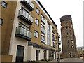
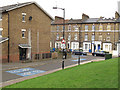
Old tower, new housing
The grade 2 listed water tower is all that is left of this former workhouse site - for a more detailed history see Image It contrasts with the new apartments on the rest of the site.
Image: © Stephen Craven
Taken: 10 Mar 2012
0.02 miles
3
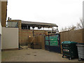
Covered washing line
I am unsure whether the building shown here - with washing hung beneath its roof - is part of the original workhouse/hospital - see Image - or part of the new development but using period architectural ironwork.
Image: © Stephen Craven
Taken: 10 Mar 2012
0.03 miles
4
Brook Drive by Austral Street
Brook Drive by Austral Street heading towards the Elephant And Castle
Image: © Shaun Ferguson
Taken: 19 Feb 2008
0.04 miles
5
Former Lambeth Hospital, Brook Drive
In fact built as the central block of Lambeth Workhouse in 1870-71. Given its function, a surprisingly flamboyant affair of yellow stock brick with red brick, stone and terracotta dressings. Grade II listed.
Much of the workhouse has since gone, what remained was subsumed into Lambeth Infirmary, and is now being converted into flats.
Image: © Stephen Richards
Taken: 12 Mar 2011
0.05 miles
6
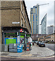
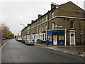
Corner shop Brook Drive and Hayles Street
A typical corner shop, general store and newsagent.
Image: © David P Howard
Taken: 24 Jan 2016
0.06 miles
7
Castilla, Elephant and Castle, Churchyard Row
Taken from St Mary's Churchyard
Image: © Robin Sones
Taken: 29 Aug 2018
0.07 miles
8
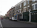
Churchyard Row, Newington
This street takes its name from the closed churchyard opposite Image This photo shows the old and new houses on opposite sides of Brook Drive, and the markings for Cycle Superhighway 7 that passes this way.
Image: © Stephen Craven
Taken: 10 Mar 2012
0.07 miles
9
Brook Street
Looking west from the corner of Oswin Street.
Image: © The Saunterer
Taken: 21 Nov 2012
0.07 miles
10
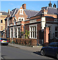
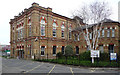
Former Lambeth Magistrates Court building, Renfrew Road
Grade II listed building from 1869. Architect: Thomas Charles Sorby. Description at this https://historicengland.org.uk/listing/the-list/list-entry/1251239. Currently a Buddhist Centre and cafe.
Image: © Jim Osley
Taken: 17 Jan 2018
0.08 miles