IMAGES TAKEN NEAR TO
King James Street, LONDON, SE1 0RU
Introduction
This page details the photographs taken nearby to King James Street, SE1 0RU by members of the Geograph project.
The Geograph project started in 2005 with the aim of publishing, organising and preserving representative images for every square kilometre of Great Britain, Ireland and the Isle of Man.

There are currently over 7.5m images from over14,400 individuals and you can help contribute to the project by visiting https://www.geograph.org.uk
Image Map
Images are licensed for reuse under creativecommons.org/licenses/by-sa/2.0
Notes
- Clicking on the map will re-center to the selected point.
- The higher the marker number, the further away the image location is from the centre of the postcode.
Image Listing (306 Images Found)
Images are licensed for reuse under creativecommons.org/licenses/by-sa/2.0
Image
Details
Distance
1
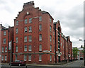
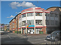
Hunter House, King James Street
Within three years, the London County Council had moved from Image] to this, by Joseph, Son & Smithem, 1899. There are some interesting details, particularly to the return wall, but the overall impression is less homely.
Image: © Stephen Richards
Taken: 5 May 2013
0.02 miles
2
Bankside community garden, King James Street
The garden is run by the Bankside Open Spaces Trust http://www.bost.org.uk/
Image: © Stephen Craven
Taken: 12 Aug 2008
0.02 miles
3
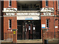
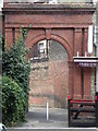
Entrance to Hunter House
Hunter House on King James Street is one of several blocks built by the London County Council around 1900, as shown by the prominent "LCC-1899" either side of the entrance.
Image: © Stephen Craven
Taken: 12 Aug 2008
0.02 miles
4
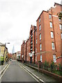
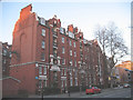
King James Street, Southwark
King James Street in inner south east London. The Shard is visible in the background.
Image: © Malc McDonald
Taken: 26 Oct 2020
0.02 miles
5
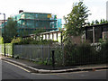
Gateway Training Centre, Lancaster Street
The centre was built on the site of St Alphege's church after the church was demolished in 1991. The church dated from 1882 but was declared redundant in 1983. The site is still "church land".
Image: © Stephen Craven
Taken: 12 Aug 2008
0.03 miles
6
Murphy House
A housing block on Borough Road, opposite South Bank University. Note the remarkable nest of chimneys at the end of the building.
Image: © Stephen Craven
Taken: 4 Mar 2010
0.03 miles
8
The Bridge Hotel, Borough Road
A hotel on the corner of Lancaster Street and Borough Road.
Image: © Stephen Craven
Taken: 4 Mar 2010
0.04 miles
9
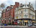
Bridge Hotel, Borough Road
Built as a pub for Watney Combe Reid in 1898, unusually in white brick.
Next door, Murphy House, looks like a London County Council block of flats of a similar vintage (e.g. compare Image]).
Image: © Stephen Richards
Taken: 6 May 2013
0.04 miles
10
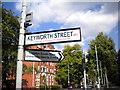
Street signs, Borough Road SE1
At the junction with Keyworth Street
Image: © Robin Sones
Taken: 8 Aug 2011
0.05 miles