IMAGES TAKEN NEAR TO
Pepper Street, LONDON, SE1 0EW
Introduction
This page details the photographs taken nearby to Pepper Street, SE1 0EW by members of the Geograph project.
The Geograph project started in 2005 with the aim of publishing, organising and preserving representative images for every square kilometre of Great Britain, Ireland and the Isle of Man.

There are currently over 7.5m images from over14,400 individuals and you can help contribute to the project by visiting https://www.geograph.org.uk
Image Map
Images are licensed for reuse under creativecommons.org/licenses/by-sa/2.0
Notes
- Clicking on the map will re-center to the selected point.
- The higher the marker number, the further away the image location is from the centre of the postcode.
Image Listing (545 Images Found)
Images are licensed for reuse under creativecommons.org/licenses/by-sa/2.0
Image
Details
Distance
1
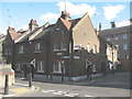
Winchester Cottages, Copperfield Street
The street was originally named Orange Street and renamed in recent years to reflect the Dickens heritage of the area. The cottages are a 19th century survival.
Image: © Stephen Craven
Taken: 12 Aug 2008
0.01 miles
2
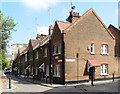
Winchester Cottages, Copperfield Street, Southwark
Image: © Jim Osley
Taken: 13 May 2016
0.01 miles
3
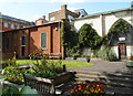
All Hallows Church garden, Southwark
The garden is situated on land owned by Southwark Cathedral within the bombed-out nave of All Hallows Church in Southwark, London. Unfortunately currently it is not open to the public, the reason being, according to a notice attached to the entrance, persistent anti-social behaviour. For a brief history of the church see this http://www.londonhistorygroup.com/?job_listing=all-hallows-church-southwark.
Image: © Jim Osley
Taken: 13 May 2016
0.02 miles
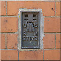
4
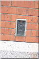
Benchmark on London Fire Brigade building, Copperfield Street
Ordnance Survey flush bracket benchmark described on the Bench Mark Database at http://www.bench-marks.org.uk/bm11703
Image: © Roger Templeman
Taken: 6 May 2011
0.02 miles
5
Flush Bracket, London
Flush Bracket Bench Mark on the wall of a building at the corner of Pepper Street and Copperfield Road in London.
The number on the bracket is S7173.
Further details at https://www.bench-marks.org.uk/bm11703 .
Image: © Rossographer
Taken: 14 May 2019
0.02 miles
6
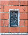
Benchmark on Royal Mail building on Pepper Street
Ordnance Survey flush bracket (identifer S7173) benchmark described on the Bench Mark Database at www.bench-marks.org.uk/bm11703
Image: © phil Richards
Taken: 7 Feb 2020
0.02 miles
7

Winchester Cottages, Copperfield Street
One of a number of housing experiments influenced by proximity to the ideas of Octavia Hill (e.g. Image]). These were built by Cluttons in 1893-95 for the Ecclesiastical Commissioners.
Image: © Stephen Richards
Taken: 5 May 2013
0.02 miles
8
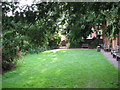
All Hallows Garden
The garden is on the site of the nave of Image Only one aisle of the church survived WW2 bombing (at the right of the photo).
Image: © Stephen Craven
Taken: 21 Aug 2008
0.02 miles
9

Drill tower at London Fire Brigade training centre
The tower is in the grounds of the training centre on Southwark Bridge Road Image
Image: © Stephen Craven
Taken: 4 Mar 2010
0.02 miles
10
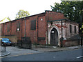
Former All Hallows Church, Copperfield Street
The church was built 1880-1892; the architect was the younger G G Scott.
Only the North aisle survived World War 2, and it was partially restored after
1956 to seat 150 with the churchyard given over as a public open space. It closed as a church in 1971 but is still consecrated. Uses since closure have included a recording studio and charity offices but it is presently vacant.
Image: © Stephen Craven
Taken: 12 Aug 2008
0.02 miles