IMAGES TAKEN NEAR TO
St. Georges Circus, LONDON, SE1 0AP
Introduction
This page details the photographs taken nearby to St. Georges Circus, SE1 0AP by members of the Geograph project.
The Geograph project started in 2005 with the aim of publishing, organising and preserving representative images for every square kilometre of Great Britain, Ireland and the Isle of Man.

There are currently over 7.5m images from over14,400 individuals and you can help contribute to the project by visiting https://www.geograph.org.uk
Image Map
Images are licensed for reuse under creativecommons.org/licenses/by-sa/2.0
Notes
- Clicking on the map will re-center to the selected point.
- The higher the marker number, the further away the image location is from the centre of the postcode.
Image Listing (391 Images Found)
Images are licensed for reuse under creativecommons.org/licenses/by-sa/2.0
Image
Details
Distance
1
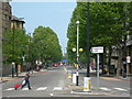
Blackfriars Road, SE1 (1)
Viewed from St George's Circus.
Image: © Danny P Robinson
Taken: 4 May 2007
0.02 miles
2
St George's Circus roundabout
Taken from London Road looking across the roundabout to Blackfriars Road.
Image: © Robin Sones
Taken: 4 Apr 2020
0.02 miles
3
Obelisk, St. George's Circus, Southwark
https://en.wikipedia.org/wiki/St_George's_Circus
Image: © Chris Whippet
Taken: 25 Jan 2016
0.02 miles
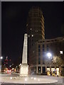
5
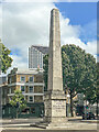
Obelisk, St George's Circus
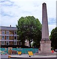
Obelisk in the centre of St George's Circus. It was erected in 1771, designed by Robert Mylne who was also responsible for Blackfriars Bridge. In 1897 it was removed to be replaced by a clock tower to commemorate Queen Victoria's Diamond Jubilee, and was subsequently re-erected in 1905 in front of what is now the Imperial War Museum (then the Bethlem Royal Hospital). It was returned to its original position in 1998. Grade II* listed - see https://historicengland.org.uk/listing/the-list/list-entry/1385642?section=official-list-entry.
Image: © Ian Capper
Taken: 3 Aug 2022
0.03 miles
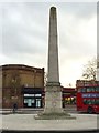
6
Obelisk at St George's Circus
Erected in the XI (11th) year of the reign of King George the 3rd. MDCCLXXI (1771). The inscriptions indicate distances of (approximately) one mile to Westminster, Fleet Street, and London Bridge.
When I studied, nearby, in 1974/5, St.George’s Circus was a roundabout. Subsequently, the road layout has been modified.
Note, to the extreme right of picture, in the distance, the "Gherkin" in the City of London.
Image: © Peter Trimming
Taken: 17 Jan 2010
0.03 miles
7

Old Milestone/Obelisk on St George's Circus, Southwark
Carved stone post by the A201/A301, in parish of Southwark (Southwark District), St George's Circus, at centre of roundabout, in centre of road. Erected by the County Council in the 18th century.
Inscription reads:-
(North): ONE MILE / XXXX FEET / FROM / LONDON BRIDGE :
(West): ONE MILE / CCCL FEET / FROM / FLEET STREET / (Coat of Arms - City of London) :
(South): ONE / MILE / FROM / PALACE YARD / (W)ESTMINSTER / HALL :
(East): ERECTED IN / XIth. YEAR / OF THE REIGN / OF KING GEORGE / THE T(HIR)D) / MDCCLXXI : THE RIG(H)T HONO(U)RABLE / BRASS CROSBY ESQU(I)RE / LORD MAYOR. :
Grade II* listed.
List Entry Number: 1385642 https://historicengland.org.uk/listing/the-list/list-entry/1385642
Milestone Society National ID: SY_LP01
Image: © M Faherty
Taken: 5 May 2008
0.03 miles
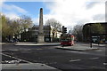
8
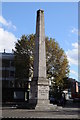
Obelisk on St George's Circus
This obelisk stands on St George's Circus at the centre of the road junction. It was designed by Robert Mylne. On the base of the obelisk is the inscription Erected in XI year of the reign of King George MDCCLXXI,
Image: © Philip Halling
Taken: 1 Nov 2014
0.03 miles
9
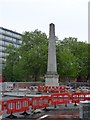
Obelisk in St George's Circus
The obelisk dates from the 18th century (1771); this side shows that it is one mile from Palace Yard. The plastic barriers and fencing date from the 21st century
Image: © David Smith
Taken: 14 May 2015
0.03 miles
10
St George's Circus, Southwark
St George's Circus is a road junction in Southwark, London, England. At its centre, which is now a traffic roundabout, is a historic obelisk, designed by Robert Mylne (1733–1811), in his role as surveyor and architect of Blackfriars Bridge. It was built in 1771 to mark the completion of the new roads through St George's Fields in the parish of Southwark St George the Martyr during the tenure of Brass Crosby as Lord Mayor of the City of London. In 1905, the obelisk was relocated to Geraldine Mary Harmsworth Park, in front of the Imperial War Museum close by, to accommodate a new clock tower. The clocktower was demolished as a "nuisance to traffic" in the 1930s, but the obelisk did not return to its original location until the late 1990s. At the base of the obelisk is the inscription Erected in XI year of the reign of King George MDCCLXXI, with the inscriptions on the other three sides reflecting the obelisk's one-mile distance from Palace Yard, London Bridge and Fleet Street. Behind the obelisk can be seen ‘The Duke of Clarence’ which is now part of the University of the South Bank.
Image: © Len Williams
Taken: 17 Jun 2015
0.03 miles