IMAGES TAKEN NEAR TO
Glyncynwal Road, SWANSEA, SA9 2UL
Introduction
This page details the photographs taken nearby to Glyncynwal Road, SA9 2UL by members of the Geograph project.
The Geograph project started in 2005 with the aim of publishing, organising and preserving representative images for every square kilometre of Great Britain, Ireland and the Isle of Man.

There are currently over 7.5m images from over14,400 individuals and you can help contribute to the project by visiting https://www.geograph.org.uk
Image Map
Images are licensed for reuse under creativecommons.org/licenses/by-sa/2.0
Notes
- Clicking on the map will re-center to the selected point.
- The higher the marker number, the further away the image location is from the centre of the postcode.
Image Listing (10 Images Found)
Images are licensed for reuse under creativecommons.org/licenses/by-sa/2.0
Image
Details
Distance
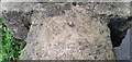
2
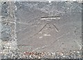
Ordnance Survey Cut Mark
This OS cut mark can be found on the wall north side of the road. It marks a point 102.654m above mean sea level.
Image: © Adrian Dust
Taken: 17 Jun 2020
0.05 miles
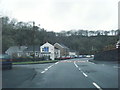
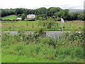
3
Lower Brynmorgan bridge
The northbound carriageway crosses over the Twrch for a few hundred yards and then crosses back over a similar bridge just visible upstream in the background. The southbound doesn't cross the river at all because it uses the path of an old railway.
Image: © Nigel Davies
Taken: 22 Jun 2008
0.06 miles
4
Ordnance Survey Cut Mark
This OS cut mark can be found on No69 Heol Gleien. It marks a point 332.6ft above mean sea level.
Image: © Adrian Dust
Taken: 17 Jun 2020
0.10 miles
5
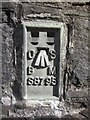
Ordnance Survey Flush Bracket
This OS Flush Bracket can be found on the roadside wall of Heol Gleien. It marks a point 101.0778m above mean sea level.
Image: © Adrian Dust
Taken: 1 Jun 2013
0.12 miles
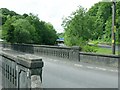
6
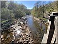
Afon Twrch
View of Afon Twrch from the Upper Bryn-Morgan Bridge. At this point the river forms the county boundary between Carmarthenshire and Powys. A few miles downstream it flows into the unitary authority of Swansea.
Image: © Alan Hughes
Taken: 15 Apr 2020
0.13 miles
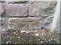
7
Ordnance Survey Rivet
This OS rivet can be found on the SE parapet of the Upper Bryn-Morgan Bridge. It marks a point 358.69ft above mean sea level.
Image: © Adrian Dust
Taken: 19 Jun 2020
0.14 miles
8
Llwybr yn cwrdd a'r heol / Path joins the road
Llwybr cyhoeddus yn cwrdd a heol ger pentre Rhiwfawr.
A public footpath joins the road near the village of Rhiwfawr (trans. big hill).
Image: © Alan Richards
Taken: 14 Jul 2020
0.20 miles
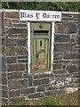
9
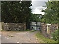
Plas y Darren
Entrance to the secluded Plas y Darren.
Image: © Alan Hughes
Taken: 14 Jul 2019
0.24 miles
10
Letter Box
George V letter box WB106/3 manufactured in 1934-6 by W.T. Allen & Co. Ltd. of London.
Image: © Alan Hughes
Taken: 14 Jul 2019
0.24 miles