IMAGES TAKEN NEAR TO
Rhiw Road, SWANSEA, SA9 2RE
Introduction
This page details the photographs taken nearby to Rhiw Road, SA9 2RE by members of the Geograph project.
The Geograph project started in 2005 with the aim of publishing, organising and preserving representative images for every square kilometre of Great Britain, Ireland and the Isle of Man.

There are currently over 7.5m images from over14,400 individuals and you can help contribute to the project by visiting https://www.geograph.org.uk
Image Map
Images are licensed for reuse under creativecommons.org/licenses/by-sa/2.0
Notes
- Clicking on the map will re-center to the selected point.
- The higher the marker number, the further away the image location is from the centre of the postcode.
Image Listing (5 Images Found)
Images are licensed for reuse under creativecommons.org/licenses/by-sa/2.0
Image
Details
Distance
1
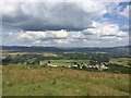
Pen Rhiw Fawr
View over Pen Rhiw Fawr towards the Brecon Beacons National Park.
Image: © Alan Hughes
Taken: 14 Jul 2019
0.04 miles
2
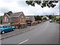
Hen Ysgol Gynradd Rhiwfawr / Former Rhiwfawr Primary School
Agorwyd Ysgol Gynradd Rhiwfawr yn 1906 ac fe'i caewyd oddeutu 2011. Addysgid y plant yn bennaf drwy gyfrwng y Gymraeg.
Rhiwfawr Primary School opened in 1906 and finally closed around 2011. The learning was mainly through the medium of Welsh
Image: © Alan Richards
Taken: 14 Jul 2020
0.09 miles
3
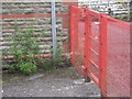
Ordnance Survey Cut Mark
This OS cut mark can just be seen adjacent to red fence on the wall of the school. It marks a point 207.3311m above mean sea level.
Image: © Adrian Dust
Taken: 29 Aug 2013
0.11 miles
4
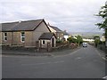
Pen-Rhiw-fawr's main street
The chapel in the foreground is Rhiwfawr, Capel yr Annibynwyr (Rhiwfawr Baptist Chapel), built in 1876.
Image: © Hywel Williams
Taken: 13 Jun 2009
0.11 miles
5
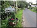
Cyrraedd Rhiwfawr / Entering Rhiwfawr
Cyrraedd pentref Rhiwfawr.
Entering the village of Rhiwfawr (trans. big hill).
Image: © Alan Richards
Taken: 14 Jul 2020
0.20 miles