IMAGES TAKEN NEAR TO
Gurnos Road, SWANSEA, SA9 2JR
Introduction
This page details the photographs taken nearby to Gurnos Road, SA9 2JR by members of the Geograph project.
The Geograph project started in 2005 with the aim of publishing, organising and preserving representative images for every square kilometre of Great Britain, Ireland and the Isle of Man.

There are currently over 7.5m images from over14,400 individuals and you can help contribute to the project by visiting https://www.geograph.org.uk
Image Map (Loading...)


Getting Data...Please wait
Leaflet Map data © OpenStreetMap
Images are licensed for reuse under creativecommons.org/licenses/by-sa/2.0
Notes
- Clicking on the map will re-center to the selected point.
- The higher the marker number, the further away the image location is from the centre of the postcode.
Image Listing (22 Images Found)
Images are licensed for reuse under creativecommons.org/licenses/by-sa/2.0
Image
Details
Distance
1
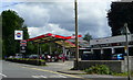
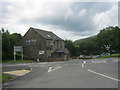
Broadway Garage and filling station
South side of Gurnos Road, Glan-rhyd.
Image: © Jonathan Billinger
Taken: 8 Aug 2008
0.01 miles
2
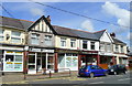
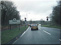
Row of shops
Gurnos Road, Glan-rhyd, looking north.
Image: © Jonathan Billinger
Taken: 8 Aug 2008
0.03 miles
3
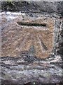
Ordnance Survey Cut Mark
This OS cut mark can be found on the parapet of the Afon Twrch Bridge. It marks a point 71.003m above mean sea level.
Image: © Adrian Dust
Taken: 15 Aug 2013
0.06 miles
4
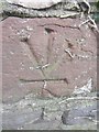
Ordnance Survey Cut Mark (Inverted)
This Inverted OS cut mark can be found on the wall at the Maes Y Coed road junction. It marks a point 71.281m above mean sea level.
Image: © Adrian Dust
Taken: 15 Aug 2013
0.07 miles
5
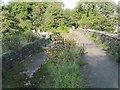
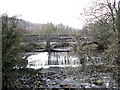
On Swansea Canal aqueduct over the Twrch at Gurnos
This portion of the disused canal is now dry but the south side towpath is a public footpath and may even be part of the mercurial cycle route 43.
Image: © Nigel Davies
Taken: 10 Sep 2009
0.08 miles
6
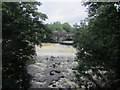
Aqueduct & River Twrch
After heavy rain.
Image: © Adrian Dust
Taken: 15 Aug 2013
0.08 miles
7
Swansea Canal Aqueduct at Ystalyfera
The Ystalyfera aqueduct is reputed to be the first built with waterproof mortar. The canal has been turned into a cycletrack in Ystalyfera: see Image The structure was recently renovated at great expense.
The Swansea Canal was constructed by the Swansea Canal Navigation Company between 1794 and 1798, measuring some 16 miles long and running from Swansea to Hen Neuadd Abercraf.
Image: © John B
Taken: 10 Dec 2004
0.09 miles