IMAGES TAKEN NEAR TO
St. Davids Road, SWANSEA, SA9 2JQ
Introduction
This page details the photographs taken nearby to St. Davids Road, SA9 2JQ by members of the Geograph project.
The Geograph project started in 2005 with the aim of publishing, organising and preserving representative images for every square kilometre of Great Britain, Ireland and the Isle of Man.

There are currently over 7.5m images from over14,400 individuals and you can help contribute to the project by visiting https://www.geograph.org.uk
Image Map
Images are licensed for reuse under creativecommons.org/licenses/by-sa/2.0
Notes
- Clicking on the map will re-center to the selected point.
- The higher the marker number, the further away the image location is from the centre of the postcode.
Image Listing (27 Images Found)
Images are licensed for reuse under creativecommons.org/licenses/by-sa/2.0
Image
Details
Distance
1
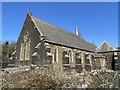
St David?s Church
Parish church of St David, Ystalyfera.
Image: © Alan Hughes
Taken: 26 Mar 2020
0.06 miles
2
St David?s Church
St David’s Church, Ystalyfera.
Image: © Alan Hughes
Taken: 26 Mar 2020
0.06 miles
3
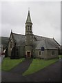
St David's Church
There is an OS cut mark on the tower. http://www.geograph.org.uk/photo/3601115
Image: © Adrian Dust
Taken: 15 Aug 2013
0.06 miles
4
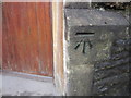
Ordnance Survey Cut Mark
This OS cut mark can be found on the corner of the school. It marks a point 64.487m above mean sea level.
Image: © Adrian Dust
Taken: 15 Aug 2013
0.07 miles
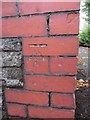
5
Ordnance Survey Cut Mark
This OS cut mark can be found on the tower of St David's Church. It marks a point 69.424m above mean sea level. http://www.geograph.org.uk/photo/3601124
Image: © Adrian Dust
Taken: 15 Aug 2013
0.08 miles
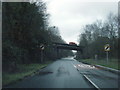
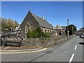
7
Glan Yr Afon, Ystalyfera
By the main entrance to Ysgol Gyfun, Ystalyfera, looking north.
Image: © Jonathan Billinger
Taken: 8 Aug 2008
0.12 miles
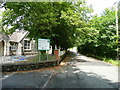
8
Tirbach Road
House on Tirbach Road, Ystalyfera. The road leads to the site of a disused colliery.
Image: © Alan Hughes
Taken: 26 Mar 2020
0.12 miles
9
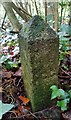
Boundary Stone
County Boundary Marker #6 between Afon Twrch and Afon Tawe.
Image: © Adrian Dust
Taken: 4 Nov 2018
0.14 miles
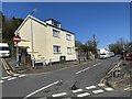
10
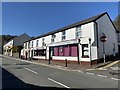
Commercial Street
Shops in Commercial Street, Ystalyfera.
Image: © Alan Hughes
Taken: 26 Mar 2020
0.14 miles