IMAGES TAKEN NEAR TO
Walters Road, SWANSEA, SA9 2FG
Introduction
This page details the photographs taken nearby to Walters Road, SA9 2FG by members of the Geograph project.
The Geograph project started in 2005 with the aim of publishing, organising and preserving representative images for every square kilometre of Great Britain, Ireland and the Isle of Man.

There are currently over 7.5m images from over14,400 individuals and you can help contribute to the project by visiting https://www.geograph.org.uk
Image Map (Loading...)


Getting Data...Please wait
Leaflet Map data © OpenStreetMap
Images are licensed for reuse under creativecommons.org/licenses/by-sa/2.0
Notes
- Clicking on the map will re-center to the selected point.
- The higher the marker number, the further away the image location is from the centre of the postcode.
Image Listing (8 Images Found)
Images are licensed for reuse under creativecommons.org/licenses/by-sa/2.0
Image
Details
Distance
1
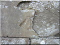
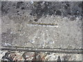
Ordnance Survey Cut Mark
The remains of this OS Cut Mark can be found on the front of the Methodist Chapel. It marks a point 162.9711m above mean sea level.
Image: © Adrian Dust
Taken: 7 Jul 2013
0.11 miles
2
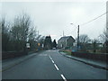
Seasons Greetings on the A4068 at Cwmllynfell
Image: © Colin Pyle
Taken: 31 Dec 2012
0.11 miles
3
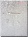
Ordnance Survey Cut Mark
This OS Cut Mark can be found on the front of Y Boblen. The Pub was once called The Mountain Hare. It marks a point 170.2369m above mean sea level.
Image: © Adrian Dust
Taken: 7 Jul 2013
0.15 miles
4
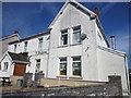
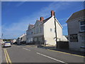
Y Boblen/The Mountain Hare
Cwmllynfell Inn which was once known as The Mountain Hare.
Image: © Adrian Dust
Taken: 7 Jul 2013
0.15 miles
5
Jenkins Ironmonger Shop
This building, Commerce House, was once the Ironmongers Shop of Mr Llewellyn J Jenkins. He was also a House furnisher & Sanitary Engineer.
Image: © Adrian Dust
Taken: 7 Jul 2013
0.15 miles
6
Ordnance Survey Cut Mark
This Ordnance Survey Cut Mark can be found left of the entrance to St Margaret's Church. It marks a point 161.3865m above mean sea level.
Image: © Adrian Dust
Taken: 1 Jun 2013
0.20 miles
7
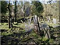
Derelict Cemetery
The older derelict Cwmllynfell cemetery, which is reached by following a footpath beyond the modern cemetery.
Image: © Hywel Williams
Taken: 27 Mar 2002
0.22 miles
8
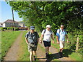
Llwybr Ystradowen Path
Cerddwyr yn dilyn llwybr cyhoeddus yn Ystradowen tuag at y mynydd agored.
Walkers following a public footpath in Ystadowen (trans. Owen's vale) towards the open countryside.
Image: © Alan Richards
Taken: 27 May 2012
0.22 miles