IMAGES TAKEN NEAR TO
Maes Y Darren, SWANSEA, SA9 2ED
Introduction
This page details the photographs taken nearby to Maes Y Darren, SA9 2ED by members of the Geograph project.
The Geograph project started in 2005 with the aim of publishing, organising and preserving representative images for every square kilometre of Great Britain, Ireland and the Isle of Man.

There are currently over 7.5m images from over14,400 individuals and you can help contribute to the project by visiting https://www.geograph.org.uk
Image Map (Loading...)


Getting Data...Please wait
Leaflet Map data © OpenStreetMap
Images are licensed for reuse under creativecommons.org/licenses/by-sa/2.0
Notes
- Clicking on the map will re-center to the selected point.
- The higher the marker number, the further away the image location is from the centre of the postcode.
Image Listing (23 Images Found)
Images are licensed for reuse under creativecommons.org/licenses/by-sa/2.0
Image
Details
Distance
1
Ysgol Gyfun Ystalyfera
A Welsh-medium community comprehensive school for 11 to 18 year-olds.
Image: © Jonathan Billinger
Taken: 8 Aug 2008
0.03 miles
2
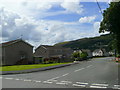
Ffordd Glandwr
Housing on the Tawe valley floor at Ystalyfera.
Image: © Jonathan Billinger
Taken: 8 Aug 2008
0.06 miles
3
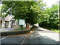
Glan Yr Afon, Ystalyfera
By the main entrance to Ysgol Gyfun, Ystalyfera, looking north.
Image: © Jonathan Billinger
Taken: 8 Aug 2008
0.06 miles
4
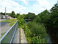
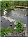
River Twrch
Looking north from Glan Yr Afon road, Ystalyfera.
Image: © Jonathan Billinger
Taken: 8 Aug 2008
0.09 miles
5
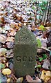
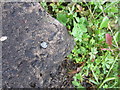
Ordnance Survey Cut Mark
This OS cut mark can be found on the corner of the school. It marks a point 64.487m above mean sea level.
Image: © Adrian Dust
Taken: 15 Aug 2013
0.11 miles
6
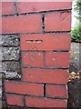
Ordnance Survey Rivet
This OS rivet can be found on the step of a small brick building between the road and the river. It marks a point 60.619m above mean sea level.
Image: © Adrian Dust
Taken: 15 Aug 2013
0.14 miles
7
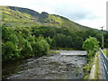
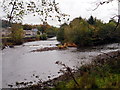
Confluence of the Twrch with the Tawe
Looking south towards the hillside of Y Darren Widdon.
Image: © Jonathan Billinger
Taken: 8 Aug 2008
0.16 miles
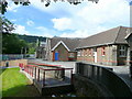
8
Weir at Abertwrch
This weir is right at the end of the Twrch where it joins the Tawe.
Image: © Nigel Davies
Taken: 30 May 2010
0.16 miles
9
Abertwrch
Man lle mae Afon twrch (ar y chwith) yn llifo i mewn i Afon Tawe.
Location where the Twrch River (trans. boar) flows into the Tawe (on the right).
Image: © Alan Richards
Taken: 2 Jan 2015
0.17 miles