IMAGES TAKEN NEAR TO
The Gardens, SWANSEA, SA9 2EA
Introduction
This page details the photographs taken nearby to The Gardens, SA9 2EA by members of the Geograph project.
The Geograph project started in 2005 with the aim of publishing, organising and preserving representative images for every square kilometre of Great Britain, Ireland and the Isle of Man.

There are currently over 7.5m images from over14,400 individuals and you can help contribute to the project by visiting https://www.geograph.org.uk
Image Map (Loading...)


Getting Data...Please wait
Leaflet Map data © OpenStreetMap
Images are licensed for reuse under creativecommons.org/licenses/by-sa/2.0
Notes
- Clicking on the map will re-center to the selected point.
- The higher the marker number, the further away the image location is from the centre of the postcode.
Image Listing (17 Images Found)
Images are licensed for reuse under creativecommons.org/licenses/by-sa/2.0
Image
Details
Distance
1
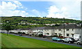
Minyrafon, Ystalyfera
Housing on the Tawe valley floor looking west.
Image: © Jonathan Billinger
Taken: 8 Aug 2008
0.16 miles
2
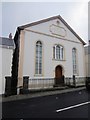
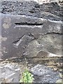
Capel Y Wern
There is an OS rivet with arrow on the wall of the chapel. http://www.geograph.org.uk/photo/3601185
Image: © Adrian Dust
Taken: 15 Aug 2013
0.16 miles
3
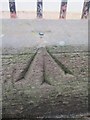
Ordnance Survey Rivet
This OS rivet can be found on the wall of Capel Y Wern. It marks a point 96.338m above mean sea level. http://www.geograph.org.uk/photo/3601192
Image: © Adrian Dust
Taken: 15 Aug 2013
0.16 miles
4

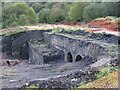
Ruins of Ystalyfera Iron Works
The ASDA construction that revealed the iron works visible in Image is now complete. The original stonework has been partially re-buried leaving the tops of the furnace arches visible. All of the low walls and passages that had been discovered are now completely buried. While some of the ruins are under the new landscaping some must be under the delivery yard.
Image: © Nigel Davies
Taken: 6 Jan 2013
0.17 miles
5
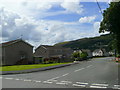
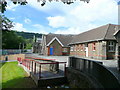
Ffordd Glandwr
Housing on the Tawe valley floor at Ystalyfera.
Image: © Jonathan Billinger
Taken: 8 Aug 2008
0.17 miles
6
Ordnance Survey Cut Mark
This OS cut mark can be found on the remains of a pillar at the end of a roadside wall on Glanyrafon Rd. It marks a point 60.859m above mean sea level.
Image: © Adrian Dust
Taken: 15 Aug 2013
0.17 miles
7
Excavated Iron Works at Ystalyfera
Asda recently started preliminary work on this area adjacent to the site of a demolished factory. They started clearing this long overgrown coal tip but discovered the remnants of Ystalyfera Iron Works. In its distant heyday it was the largest iron works in the world at the time. No further progress has been made on the supermarket and the historic site has now been fenced off. It seems that Asda have been forced to preserve the historic remains if they are to continue development.
Image: © Nigel Davies
Taken: 18 Sep 2011
0.18 miles
8
Ysgol Gyfun Ystalyfera
A Welsh-medium community comprehensive school for 11 to 18 year-olds.
Image: © Jonathan Billinger
Taken: 8 Aug 2008
0.18 miles
9
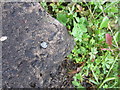
Ordnance Survey Rivet
This OS rivet can be found on the step of a small brick building between the road and the river. It marks a point 60.619m above mean sea level.
Image: © Adrian Dust
Taken: 15 Aug 2013
0.20 miles
10
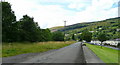
Glan yr Afon, Ystalyfera
Looking along the road to Mynydd Allt-y-grug (338m), which overlooks the Swansea Valley.
Image: © Jonathan Billinger
Taken: 8 Aug 2008
0.20 miles