IMAGES TAKEN NEAR TO
Ffordd Y Glowyr, SWANSEA, SA9 2BQ
Introduction
This page details the photographs taken nearby to Ffordd Y Glowyr, SA9 2BQ by members of the Geograph project.
The Geograph project started in 2005 with the aim of publishing, organising and preserving representative images for every square kilometre of Great Britain, Ireland and the Isle of Man.

There are currently over 7.5m images from over14,400 individuals and you can help contribute to the project by visiting https://www.geograph.org.uk
Image Map
Images are licensed for reuse under creativecommons.org/licenses/by-sa/2.0
Notes
- Clicking on the map will re-center to the selected point.
- The higher the marker number, the further away the image location is from the centre of the postcode.
Image Listing (14 Images Found)
Images are licensed for reuse under creativecommons.org/licenses/by-sa/2.0
Image
Details
Distance
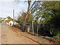
2
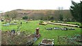
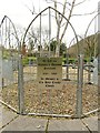
Graveyard of former Holy Trinity Church, Ystalyfera
Holy Trinity church was built in 1845 and demolished in 1988 because it was structurally unsound. The graveyard has remained and a memorial garden has replaced the demolished church, giving an idea of its original position. The fence around the tree at the centre of the garden has a plaque, shown here: Image
This photo was taken from the adjacent Church Road.
See http://www.ystalyfera-history.co.uk/holy-trinity-ystalyfera.html for more details.
Image: © Nigel Davies
Taken: 28 Feb 2016
0.19 miles
3
Mynwent eglwys / Church burial ground
Mynwent Eglwys y Drindod Sanctaidd. Dymchwelwyd yr eglwys yn 1988.
The burial ground of the Holy Trinity Church. The church itself was demolished in 1988.
Image: © Alan Richards
Taken: 23 Oct 2018
0.19 miles
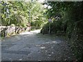
4
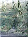
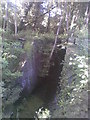
St Illtyd's Way leaves Sustrans cycle route 43
This unassuming little series of steps is where St. Illtyd's Way parts way with the cycle route. It was clear that few people walk this route as it was blocked in several places with fallen trees and there were few footprints in some of the muddy tracks.
Image: © Hywel Williams
Taken: 4 Feb 2007
0.19 miles
5
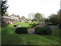
Plaque in Holy Trinity memorial garden, Ystalyfera
A plaque mounted on a fence at the centre of the cross-shaped garden pictured here: Image
The plaque gives the dates of the demolished church.
Image: © Nigel Davies
Taken: 28 Feb 2016
0.19 miles
6
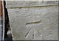
Ordnance Survey Cut Mark
This OS cut mark can be found on the old Post Office. It marks a point 85.384m above mean sea level.
Image: © Adrian Dust
Taken: 16 Oct 2016
0.19 miles
7
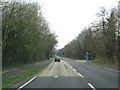
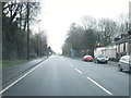
Road Junction With Lights On A4067
Traffic Lights recently installed (2005) at junction.
Image: © Bonelli
Taken: 4 Apr 2007
0.19 miles
8
Swansea Canal Lockgate
Swansea Canal lockgate at Godrer Graig (Swansea Canal Walk).
Image: © Tawe Tours
Taken: Unknown
0.20 miles
9
Llwybr yn gadael yr heol / Path exiting the road
Llwybr cyhoeddus yn gadael yr heol ym Mhant-teg ac yn mynd i gyfeiriad yr A4067.
A public footpath exiting the road at Pant-teg (trans. fair hollow) and heading for the A4067.
Image: © Alan Richards
Taken: 23 Oct 2018
0.20 miles
10
Landslide on Graig Road between Godre'r Graig and Ystalyfera
In 1965 part of Mynydd Allt-y-grug slipped down over this section of road sweeping away all the houses either side of it. The road has only ever been reopened as a much narrower path for light foot traffic.
In the photo you can see how much the landslide has reduced the width of the road. However this is not the whole story: a few hundred yards further back the road is a third wider again with a pavement on both sides.
The landslide is thought to have been triggered when a water main supply was accidentally ruptured, allowing water between layers of otherwise impermeable rock. Even now at the southwest end of the landslip there are extra drainage pipes running down the mountain to help prevent further occurrences.
Image: © Nigel Davies
Taken: 10 Sep 2009
0.21 miles