IMAGES TAKEN NEAR TO
Bron Yr Allt, SWANSEA, SA9 2AY
Introduction
This page details the photographs taken nearby to Bron Yr Allt, SA9 2AY by members of the Geograph project.
The Geograph project started in 2005 with the aim of publishing, organising and preserving representative images for every square kilometre of Great Britain, Ireland and the Isle of Man.

There are currently over 7.5m images from over14,400 individuals and you can help contribute to the project by visiting https://www.geograph.org.uk
Image Map
Images are licensed for reuse under creativecommons.org/licenses/by-sa/2.0
Notes
- Clicking on the map will re-center to the selected point.
- The higher the marker number, the further away the image location is from the centre of the postcode.
Image Listing (11 Images Found)
Images are licensed for reuse under creativecommons.org/licenses/by-sa/2.0
Image
Details
Distance
1
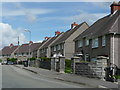
Pen-yr-grug
Housing high above the Tawe Valley north of Ystatyfera.
Image: © Jonathan Billinger
Taken: 8 Aug 2008
0.03 miles
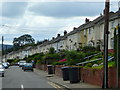
2
Penyralltwen Park, Ystalyfera
At the crossroads with Allt-y-grug Farm Road.
Image: © Jonathan Billinger
Taken: 8 Aug 2008
0.10 miles
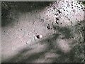
3
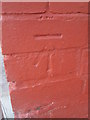
Ordnance Survey Cut Mark
This OS cut mark can be found on the NE angle of No121 Penywern. It marks a point 166.729m above mean sea level.
Image: © Adrian Dust
Taken: 11 Sep 2014
0.10 miles
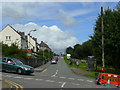
4
Penywern Road, Ystalyfera
Looking south, downhill, towards the town centre.
Image: © Jonathan Billinger
Taken: 8 Aug 2008
0.14 miles


7

Old Gateway on track to Gilfach-yr-Haidd
Image: © Adrian Dust
Taken: 2 Jun 2020
0.20 miles
8
Ordnance Survey Rivet
This OS rivet can be found at the gateway leading to footpath steps, SE of the road. It marks a point 197.916m above mean sea level. http://www.geograph.org.uk/photo/4160265
Image: © Adrian Dust
Taken: 11 Sep 2014
0.21 miles
9
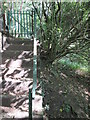
Footpath Steps & Gate
There is an Ordnance Survey rivet at the gate. http://www.geograph.org.uk/photo/4160260
Image: © Adrian Dust
Taken: 11 Sep 2014
0.21 miles
10
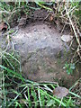
Ordnance Survey Rivet
This OS rivet can be found on a stone at the junction of track and footpath. It marks a point 223.449m above mean sea level.
Image: © Adrian Dust
Taken: 11 Sep 2014
0.21 miles