IMAGES TAKEN NEAR TO
Ynyswen, SWANSEA, SA9 1YX
Introduction
This page details the photographs taken nearby to Ynyswen, SA9 1YX by members of the Geograph project.
The Geograph project started in 2005 with the aim of publishing, organising and preserving representative images for every square kilometre of Great Britain, Ireland and the Isle of Man.

There are currently over 7.5m images from over14,400 individuals and you can help contribute to the project by visiting https://www.geograph.org.uk
Image Map (Loading...)


Getting Data...Please wait
Leaflet Map data © OpenStreetMap
Images are licensed for reuse under creativecommons.org/licenses/by-sa/2.0
Notes
- Clicking on the map will re-center to the selected point.
- The higher the marker number, the further away the image location is from the centre of the postcode.
Image Listing (24 Images Found)
Images are licensed for reuse under creativecommons.org/licenses/by-sa/2.0
Image
Details
Distance
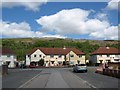
2
Ynyswen in the Tawe valley
Mynydd y Betws wind farm on the horizon.
Image: © Alan Hughes
Taken: 28 Aug 2021
0.06 miles
3
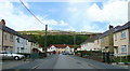
Cribarth, Ynyswen
A housing estate north of the A4067 in the upper Tawe Valley.
Image: © Jonathan Billinger
Taken: 8 Aug 2008
0.06 miles
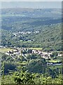
4
Southern arm of Cribarth, Ynyswen
Viewed from the A4067 (Brecon Road). Cribarth is the main residential street in the village. Most of the houses on Cribarth are in the section oriented SW to NE, at the far end of the view.
Image: © Jaggery
Taken: 21 Aug 2011
0.06 miles
5
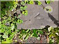
Ordnance Survey Rivet
This OS rivet can be found on the gate step of Godre Waun Oleu. It marks a point 156.974m above mean sea level.
Image: © Adrian Dust
Taken: 13 Jun 2022
0.06 miles
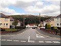
6
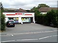
Spar, Ynyswen
The village shop is set back 10 metres from the north side of the A4067, between the turnings for Cribarth and Riverside Gardens.
Image: © Jaggery
Taken: 21 Aug 2011
0.07 miles
7
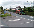
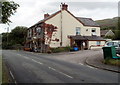
Tractor and trailer, Ynyswen
The distinctive green and yellow colours identify the tractor as a John Deere, parked on the A4067 opposite the turning for Riverside Gardens.
Image: © Jaggery
Taken: 21 Aug 2011
0.07 miles
8
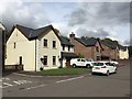
New houses in Ynyswen
A riverside development of new houses in Ynyswen.
Image: © Alan Hughes
Taken: 15 Sep 2018
0.11 miles
9
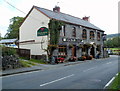
Ancient Briton viewed from the east, Ynyswen
Country inn on the A4067. It's in Ynyswen, based on the placement of village boundary signs on the A4067, though various sources located it in the next village east, Penycae.
http://www.geograph.org.uk/photo/2566605 to a view from the west.
Image: © Jaggery
Taken: 21 Aug 2011
0.13 miles
10
Ancient Briton viewed from the west, Ynyswen
Country inn on the A4067. It's in Ynyswen, based on the placement of village boundary signs on the A4067, though various sources located it in the next village east, Penycae.
http://www.geograph.org.uk/photo/2566608 to a view from the east.
Image: © Jaggery
Taken: 21 Aug 2011
0.13 miles