IMAGES TAKEN NEAR TO
Heol Rheolau, SWANSEA, SA9 1TE
Introduction
This page details the photographs taken nearby to Heol Rheolau, SA9 1TE by members of the Geograph project.
The Geograph project started in 2005 with the aim of publishing, organising and preserving representative images for every square kilometre of Great Britain, Ireland and the Isle of Man.

There are currently over 7.5m images from over14,400 individuals and you can help contribute to the project by visiting https://www.geograph.org.uk
Image Map
Images are licensed for reuse under creativecommons.org/licenses/by-sa/2.0
Notes
- Clicking on the map will re-center to the selected point.
- The higher the marker number, the further away the image location is from the centre of the postcode.
Image Listing (19 Images Found)
Images are licensed for reuse under creativecommons.org/licenses/by-sa/2.0
Image
Details
Distance
1
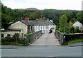
Across Gwaunclawdd bridge near Abercrave
The bridge http://www.geograph.org.uk/photo/3151673 across the River Tawe connects the row of houses with the A4067.
Image: © Jaggery
Taken: 29 Aug 2011
0.01 miles
2

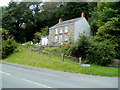
Lamb & Flag
Cerddwyr yn agosau at hen Dafarn y Lamb & Flag - yr anhedd-dy gyda'r porth.
Walkers approaching the former Lamb & Flag Public house, the property with a porch.
Image: © Alan Richards
Taken: 31 Oct 2010
0.02 miles
3

Derelict building, Gwaunclawdd near Abercrave
Located opposite these http://www.geograph.org.uk/photo/3151914 houses. A faded metal sign on the wall shows "Bass" IN BOTTLE.
Image: © Jaggery
Taken: 29 Aug 2011
0.02 miles
4
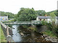
Gwaunclawdd bridge near Abercrave
The bridge across the River Tawe connects houses in Gwaunclawdd on the right with the A4067.
Image: © Jaggery
Taken: 29 Aug 2011
0.03 miles
5
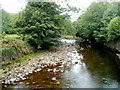
Rocky River Tawe, Abercrave
Viewed from this http://www.geograph.org.uk/photo/3151673 bridge.
Image: © Jaggery
Taken: 29 Aug 2011
0.04 miles
6
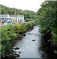
River Tawe upstream from Gwaunclawdd bridge near Abercrave
The Tawe flows towards this http://www.geograph.org.uk/photo/3151673 bridge.
The Rheolau Arms http://www.geograph.org.uk/photo/3151546 and Rheolau Arms Motors http://www.geograph.org.uk/photo/3151556 are on the left.
Image: © Jaggery
Taken: 29 Aug 2011
0.04 miles
7
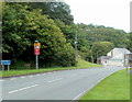
Western boundary of Abercrave
Brecon Road (the A4067) reaches Abercrave, a village in the far south of Powys, in the Upper Swansea Valley about 5km NE of Ystradgynlais. The name sign shows only the Welsh form Abercraf.
A Veolia bus depot http://www.geograph.org.uk/photo/3151641 is in the background.
Image: © Jaggery
Taken: 29 Aug 2011
0.05 miles
8

Rheolau Arms Motors, Abercrave
Garage (repairs, servicing, fuel) alongside the A4067, near the Rheola Arms pub. http://www.geograph.org.uk/photo/3151546
Image: © Jaggery
Taken: 29 Aug 2011
0.05 miles
9
A hillside house at the western edge of Abercrave
Viewed from near this http://www.geograph.org.uk/photo/3151673 river bridge.
Image: © Jaggery
Taken: 29 Aug 2011
0.06 miles
10
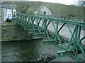
Bridge over the river Tawe west of Abercraf
This bridge joins right on to the main A4067 road. I would have said it was a wide footbridge, but the houses and cars on the other side, maybe not.
Image: © Nigel Davies
Taken: 2 Apr 2006
0.06 miles