IMAGES TAKEN NEAR TO
Ynysuchaf, Ystradgynlais, SWANSEA, SA9 1RH
Introduction
This page details the photographs taken nearby to SA9 1RH by members of the Geograph project.
The Geograph project started in 2005 with the aim of publishing, organising and preserving representative images for every square kilometre of Great Britain, Ireland and the Isle of Man.

There are currently over 7.5m images from over14,400 individuals and you can help contribute to the project by visiting https://www.geograph.org.uk
Image Map
Images are licensed for reuse under creativecommons.org/licenses/by-sa/2.0
Notes
- Clicking on the map will re-center to the selected point.
- The higher the marker number, the further away the image location is from the centre of the postcode.
Image Listing (15 Images Found)
Images are licensed for reuse under creativecommons.org/licenses/by-sa/2.0
Image
Details
Distance
1
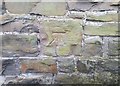
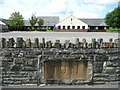
Ordnance Survey Cut Mark
This OS cut mark can be found on Chapel House, Long Street. It marks a point 97.692m above mean sea level.
Image: © Adrian Dust
Taken: 8 Jul 2020
0.07 miles
2
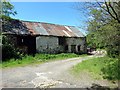
Tai Mas Ffarm Cwm Tawe / Cwm Tawe Farm Outhouses
Hen dai mas Ffarm Cwm Tawe.
Old outhouses at Cwm Tawe Farm.
Image: © Alan Richards
Taken: 7 Jun 2015
0.07 miles
3
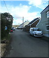
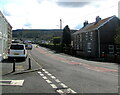
North along Cwmtawe Road, Penrhos, Powys
Cwmtawe Road is a dead end road connecting with the B4599 Brecon Road behind the camera.
Image: © Jaggery
Taken: 6 May 2021
0.15 miles
4
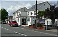
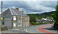
Penrhos Social Club and Institute
Brecon Road, B4599, Penrhos, near Ystradgynlais.
Image: © Jonathan Billinger
Taken: 8 Aug 2008
0.17 miles
5
East along the B4599 Brecon Road, Penrhos, Powys
Viewed from the corner of Cwmtawe Road.
Image: © Jaggery
Taken: 6 May 2021
0.18 miles
6
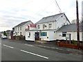
Bend in Brecon Road, Penrhos
Looking east, away from Ystradgynlais.
Image: © Jonathan Billinger
Taken: 8 Aug 2008
0.18 miles
8
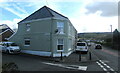
Junction of Cwmtawe Road and Brecon Road, Penrhos, Powys
From the left, Cwmtawe Road joins the B4599 Brecon Road.
Image: © Jaggery
Taken: 6 May 2021
0.19 miles
9
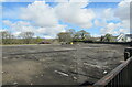
Site of a demolished school, Penrhos, Powys
Viewed in May 2021. Penrhos Primary School https://www.geograph.org.uk/photo/914146 was here in 2008.
Image: © Jaggery
Taken: 6 May 2021
0.19 miles
10
Penrhos Primary School
North of the main street of this village north of Ystradgynlais.
Image: © Jonathan Billinger
Taken: 8 Aug 2008
0.19 miles