IMAGES TAKEN NEAR TO
Brecon Road, SWANSEA, SA9 1QN
Introduction
This page details the photographs taken nearby to Brecon Road, SA9 1QN by members of the Geograph project.
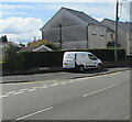
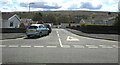
The Geograph project started in 2005 with the aim of publishing, organising and preserving representative images for every square kilometre of Great Britain, Ireland and the Isle of Man.

There are currently over 7.5m images from over14,400 individuals and you can help contribute to the project by visiting https://www.geograph.org.uk
Image Map
Images are licensed for reuse under creativecommons.org/licenses/by-sa/2.0
Notes
- Clicking on the map will re-center to the selected point.
- The higher the marker number, the further away the image location is from the centre of the postcode.
Image Listing (111 Images Found)
Images are licensed for reuse under creativecommons.org/licenses/by-sa/2.0
Image
Details
Distance
1
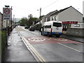
Start of the 20 zone, Brecon Road, Ystradgynlais
The 30mph speed limit on the B4599 Brecon Road drops to 20 on the approach to Ysgol Golwg y Cwm primary school. http://www.geograph.org.uk/photo/4945901
Image: © Jaggery
Taken: 10 May 2016
0.01 miles
2
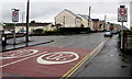
From 20 to 30 on Brecon Road, Ystradgynlais
The 20mph speed limit on the B4599 Brecon Road near a primary school increases to 30mph.
The left turn is the Richmond Park junction. http://www.geograph.org.uk/photo/4945882
Image: © Jaggery
Taken: 10 May 2016
0.01 miles
3

Start of the 20 zone, Brecon Road, Ystradgynlais
The 30mph speed limit on the B4599 Brecon Road drops to 20mph. PARTH is Welsh for ZONE.
A Premier Express store https://www.geograph.org.uk/photo/6853940 is on the right.
Image: © Jaggery
Taken: 6 May 2021
0.01 miles
4
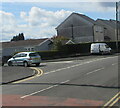
Junction of Brecon Road and Richmond Park, Ystradgynlais
From the left, Richmond Park joins the B4599 Brecon Road.
A Total Rail Solutions van https://www.geograph.org.uk/photo/6853949, is on the right.
Image: © Jaggery
Taken: 6 May 2021
0.01 miles
5
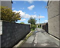
Dead-end side road in Ystradgynlais
On the west side of the B4599 Brecon Road near Penrhos.
Image: © Jaggery
Taken: 6 May 2021
0.02 miles
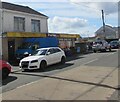
6
Total Rail Solutions white van, Brecon Road, Ystradgynlais
The business provides operated and non-operated road-rail plant, subcontracting services and labour provision to rail sites across the UK.
Image: © Jaggery
Taken: 6 May 2021
0.02 miles
7
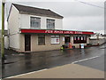
Pen Rhos Local Store, Ystradgynlais
Convenience store viewed across Brecon Road.
Image: © Jaggery
Taken: 10 May 2016
0.02 miles
8
TLT Penrhos Store, 160 Brecon Road, Ystradgynlais
Premier Express convenience store alongside the B4599 Brecon Road viewed in May 2021.
The shop looked like this https://www.geograph.org.uk/photo/4945892 in May 2016.
Image: © Jaggery
Taken: 6 May 2021
0.02 miles
9
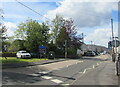
Into Ystradgynlais from Penrhos, Powys
Looking to the southwest along the B4599 Brecon Road from the edge of Penrhos.
The Ystradgynlais boundary sign is on the left
Image: © Jaggery
Taken: 6 May 2021
0.03 miles
10
Richmond Park bungalows, Ystradgynlais
Viewed across the B4599 Brecon Road in May 2021. Derived from a Hindi word meaning "in the style of Bengal", bungalow was originally used in English for a lightly-built one-storey house with a veranda. In current UK usage it is a convenient word for any one-storey dwelling.
Image: © Jaggery
Taken: 6 May 2021
0.04 miles