IMAGES TAKEN NEAR TO
Ystradgynlais, SWANSEA, SA9 1QB
Introduction
This page details the photographs taken nearby to SA9 1QB by members of the Geograph project.
The Geograph project started in 2005 with the aim of publishing, organising and preserving representative images for every square kilometre of Great Britain, Ireland and the Isle of Man.

There are currently over 7.5m images from over14,400 individuals and you can help contribute to the project by visiting https://www.geograph.org.uk
Image Map
Images are licensed for reuse under creativecommons.org/licenses/by-sa/2.0
Notes
- Clicking on the map will re-center to the selected point.
- The higher the marker number, the further away the image location is from the centre of the postcode.
Image Listing (14 Images Found)
Images are licensed for reuse under creativecommons.org/licenses/by-sa/2.0
Image
Details
Distance
1
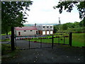
Penrhiwvarteg Scout Hostel, Ystradgynlais
The 1st Swansea Valley Oak Scouts Group owns and runs this hostel, see; http://hsmt.info/Penrhiwvarteg%20.pdf
Image: © Jonathan Billinger
Taken: 8 Aug 2008
0.06 miles
2
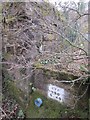
Railway Bridge Remains
Part of Buttress, all that remains of disused railway line bridge BRB YSG 5.40.
Image: © Adrian Dust
Taken: 29 Mar 2014
0.11 miles
3
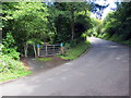
Llwybr Beicio 43 yng Nglanrhyd / Cycle Path 43 in Glanrhyd
Llwybr beicio 43 yn gadael yr heol Glanrhyd.
Cycle path 43 exiting the road above Glanrhyd (trans. bank of the ford).
Image: © Alan Richards
Taken: 7 Aug 2020
0.11 miles
4
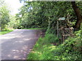
Llwybr uwchben Glanrhyd / Path above Glanrhyd
Llwybr cyhoeddus yn gadael yr heol uwchben Glanrhyd.
A public footpath exiting the road above Glanrhyd (trans. bank of the river).
Image: © Alan Richards
Taken: 7 Aug 2020
0.18 miles
5
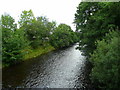
River Tawe - upstream
View north-east from Glan-rhyd Bridge
Image: © Jonathan Billinger
Taken: 8 Aug 2008
0.19 miles
6
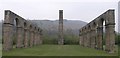
Ynyscedwyn iron works
With the many coal mines in the surrounding area, it was only natural for the heavy industry of metal working to go hand in hand. Here we see the remains of the victorian Ynyscedwyn iron works, which made use of the revolutionary hot blast process.
The arches and chimney stack are all that remain today of a large factory that sprawled across this area.
Image: © Hywel Williams
Taken: 13 Apr 2007
0.20 miles
7
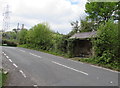
Neath Road bus shelter near Varteg Hill, southwest Powys
The shelter side of the road is for buses to Ystradgynlais and Brecon. The Varteg Hill junction is ahead.
Image: © Jaggery
Taken: 16 May 2016
0.21 miles
8
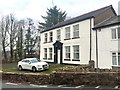
Traveller?s Rest
Formerly an inn on the outskirts of Ystradgynlais.
Image: © Alan Hughes
Taken: 27 Dec 2018
0.22 miles
9
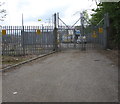
Entrance to Travellers Rest Primary electricity substation south of Ystradgynlais
From Neath Road near the Varteg Hill junction, about 500 metres south of the southern edge of Ystradgynlais. Immediately behind and above the standard metal perimeter fence is an electric fence.
The Western Power Distribution identifier is TRAVELLERS REST Primary 520041.
Image: © Jaggery
Taken: 16 May 2016
0.22 miles
10
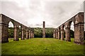
Ynyscedwyn Ironworks
Ynyscedwyn Ironworks Park was created on the site of the ironworks which made the south Wales village of Ystradgynlais famous. According to evidence found at this site, iron was being smelted here from as early as 1612. The most important period for these works was during the early nineteenth century where the hot blast method was invented here. Iron making ceased in 1941, and these soaring arches and preserved machinery are all that now remain. The pastoral landscape, overlooked by craggy hills, offers visitors peaceful respite and the opportunity to witness a rich and unique heritage hundreds of years in the making.
Image: © Alan Thomas
Taken: 20 Jul 2014
0.23 miles