IMAGES TAKEN NEAR TO
Oddfellows Street, SWANSEA, SA9 1LH
Introduction
This page details the photographs taken nearby to Oddfellows Street, SA9 1LH by members of the Geograph project.
The Geograph project started in 2005 with the aim of publishing, organising and preserving representative images for every square kilometre of Great Britain, Ireland and the Isle of Man.

There are currently over 7.5m images from over14,400 individuals and you can help contribute to the project by visiting https://www.geograph.org.uk
Image Map
Images are licensed for reuse under creativecommons.org/licenses/by-sa/2.0
Notes
- Clicking on the map will re-center to the selected point.
- The higher the marker number, the further away the image location is from the centre of the postcode.
Image Listing (106 Images Found)
Images are licensed for reuse under creativecommons.org/licenses/by-sa/2.0
Image
Details
Distance
1
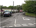
Unnamed side road, Ystradgynlais
Viewed across Heol Giedd. This side road is parallel with Oddfellows Street, 40 metres to the SW.
Image: © Jaggery
Taken: 20 May 2016
0.02 miles
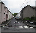
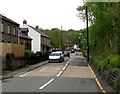
2
Oddfellows Street in Ystradgynlais
Viewed from the edge of the A4067 looking along Oddfellows
Street towards Heol Giedd on a bank of the River Tawe.
Image: © Jaggery
Taken: 20 May 2016
0.03 miles
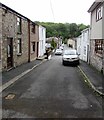
3
Oddfellows Street, Ystradgynlais
From Heol Giedd towards the A4067 (the Ystradgynlais Bypass). The name sign on the right shows ODDFELLOW STREET. It should be ODDFELLOWS STREET. The Powys Digital History Project records that Oddfellows Street took its name from the Independent Order of Oddfellows, a nationwide organisation created as part of the great movement toward friendly and benevolent societies during the late 18th and early 19th centuries.
Image: © Jaggery
Taken: 20 May 2016
0.04 miles
4
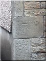
Ordnance Survey Cut Mark
This OS cut mark can be found on the front of No29 Heol Giedd. It marks a point 85.440m above mean sea level.
Image: © Adrian Dust
Taken: 15 Aug 2013
0.05 miles
5
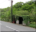
Ivy-clad phonebox and bus shelter, Ystradgynlais
In May 2016, the Heol Giedd phonebox is more green than red.
Image: © Jaggery
Taken: 20 May 2016
0.05 miles
6
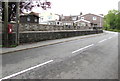
Two stone walls, Heol Giedd, Ystradgynlais
More or less parallel walls extending along the edge of Heol Giedd from
near the corner of Caedegar Road towards the corner of Oddfellows Street.
Image: © Jaggery
Taken: 20 May 2016
0.05 miles
7
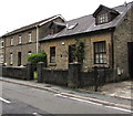
Old Courthouse, Heol Giedd, Ystradgynlais
The nameplate http://www.geograph.org.uk/photo/4964477 on the wall of the house on the right shows
1842, a depiction of a crown, HENLYS, THE OLD COURTHOUSE.
Image: © Jaggery
Taken: 20 May 2016
0.05 miles
8
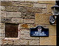
Old Courthouse nameplate, Heol Giedd, Ystradgynlais
On the wall of the house on the right here. http://www.geograph.org.uk/photo/4964471
Image: © Jaggery
Taken: 20 May 2016
0.05 miles
9
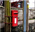
Queen Elizabeth II postbox on a pole, Heol Giedd, Ystradgynlais
On the left here. http://www.geograph.org.uk/photo/4964426
Image: © Jaggery
Taken: 20 May 2016
0.05 miles
10
20 on Heol Giedd, Ystradgynlais
The 30mph speed limit drops to 20mph on the approach to the entrance to Ysgol Cynlais Primary School. http://www.geograph.org.uk/photo/4968316
Image: © Jaggery
Taken: 20 May 2016
0.05 miles