IMAGES TAKEN NEAR TO
Commercial Street, SWANSEA, SA9 1LB
Introduction
This page details the photographs taken nearby to Commercial Street, SA9 1LB by members of the Geograph project.
The Geograph project started in 2005 with the aim of publishing, organising and preserving representative images for every square kilometre of Great Britain, Ireland and the Isle of Man.

There are currently over 7.5m images from over14,400 individuals and you can help contribute to the project by visiting https://www.geograph.org.uk
Image Map
Images are licensed for reuse under creativecommons.org/licenses/by-sa/2.0
Notes
- Clicking on the map will re-center to the selected point.
- The higher the marker number, the further away the image location is from the centre of the postcode.
Image Listing (184 Images Found)
Images are licensed for reuse under creativecommons.org/licenses/by-sa/2.0
Image
Details
Distance
1
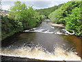
White water on the River Tawe, Ystradgynlais
The Tawe flows across two ledges. Viewed from Commercial Street.
http://www.geograph.org.uk/photo/4961825 to a more placid view on the other side of the bridge.
Image: © Jaggery
Taken: 20 May 2016
0.02 miles
2
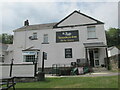
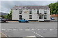
The Ynyscedwyn Arms
Public house in Ystradgynlais.
Image: © steven ruffles
Taken: 28 Jul 2022
0.03 miles
3
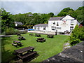
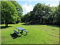
Ynyscedwyn Arms picnic benches, Ystradgynlais
On the north bank of the River Tawe, viewed from Commercial Street.
Image: © Jaggery
Taken: 20 May 2016
0.03 miles
4
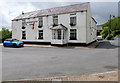
Ynyscedwyn Arms & Tawe Restaurant, Ystradgynlais
Viewed across Commercial Street from the corner of Rhestr Fawr.
http://www.geograph.org.uk/photo/4960829 to another view.
Image: © Jaggery
Taken: 20 May 2016
0.03 miles
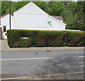
5
Ynyscedwyn Arms, Commercial Street, Ystradgynlais
Ynyscedwyn Arms & Tawe Restaurant viewed from Rhestr Fawr.
Image: © Jaggery
Taken: 20 May 2016
0.03 miles
6
Parc Coronation Park
Cerddwyr yn mynd drwy Barc Coronation, Ystradgynlais.
Walkers going through Coronation Park, Ystradgynlais (trans. vale of the Cynlais river).
Image: © Alan Richards
Taken: 7 Jun 2015
0.04 miles
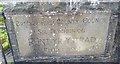
8
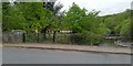
Street name in a hedge, Ystradgynlais
The name RHESTR FAWR is in the hedge at the SW end of this http://www.geograph.org.uk/photo/4960838 long dead-end street.
Image: © Jaggery
Taken: 20 May 2016
0.05 miles
10
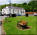
Bench and telecoms cabinets on a green, Ystradgynlais
Viewed from Heol Giedd looking towards the Ynyscedwyn Arms. https://www.geograph.org.uk/photo/6162169
Image: © Jaggery
Taken: 20 May 2016
0.05 miles