IMAGES TAKEN NEAR TO
Maes Y Cwm, SWANSEA, SA9 1JS
Introduction
This page details the photographs taken nearby to Maes Y Cwm, SA9 1JS by members of the Geograph project.
The Geograph project started in 2005 with the aim of publishing, organising and preserving representative images for every square kilometre of Great Britain, Ireland and the Isle of Man.

There are currently over 7.5m images from over14,400 individuals and you can help contribute to the project by visiting https://www.geograph.org.uk
Image Map
Images are licensed for reuse under creativecommons.org/licenses/by-sa/2.0
Notes
- Clicking on the map will re-center to the selected point.
- The higher the marker number, the further away the image location is from the centre of the postcode.
Image Listing (209 Images Found)
Images are licensed for reuse under creativecommons.org/licenses/by-sa/2.0
Image
Details
Distance
1
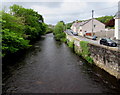
River Tawe downstream from Teddy Bear Bridge, Ystradgynlais
Viewed from this http://www.geograph.org.uk/photo/4962695 footbridge. The road is Heol Giedd.
Image: © Jaggery
Taken: 20 May 2016
0.02 miles
2
Bend in river and road, Ystradgynlais
The River Tawe and Heol Giedd viewed from the western end of this http://www.geograph.org.uk/photo/4962695 footbridge.
Image: © Jaggery
Taken: 20 May 2016
0.02 miles
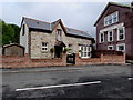
3
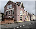
Penybont Inn, Ystradgynlais
On the north bank of the River Tawe, viewed across Heol Giedd. http://www.geograph.org.uk/photo/4962509 to another view.
Image: © Jaggery
Taken: 20 May 2016
0.03 miles
4
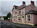
Penybont Inn, Ystradgynlais
On the north bank of the River Tawe, viewed across Heol Giedd. http://www.geograph.org.uk/photo/4961926 to another view.
Image: © Jaggery
Taken: 20 May 2016
0.04 miles
5
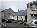
Small single-storey house, Heol Giedd, Ystradgynlais
Conspicuous between larger two-storey houses.
Image: © Jaggery
Taken: 20 May 2016
0.04 miles
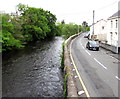
6
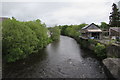
Upstream along the River Tawe, Ystradgynlais
Looking NE from Commercial Street. The flow of the river accelerates near the camera.
There is much white water http://www.geograph.org.uk/photo/4960831 on the opposite side of the bridge.
Image: © Jaggery
Taken: 20 May 2016
0.04 miles
7
The Old Coach House, Ystradgynlais
On the north bank of the River Tawe, viewed across Heol Giedd.
Penybont Inn http://www.geograph.org.uk/photo/4961926 is on the right.
Image: © Jaggery
Taken: 20 May 2016
0.04 miles
8
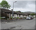
Maesycwm bungalows, Ystradgynlais
Viewed from Derwen Road. Originally, bungalow was used in English for a lightly-built house, with a veranda and one storey. In current UK usage it is a convenient word for any one-storey dwelling.
Image: © Jaggery
Taken: 20 May 2016
0.04 miles
9
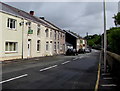
Heol Giedd houses, Ystradgynlais
The houses face the wall above the River Tawe.
Image: © Jaggery
Taken: 20 May 2016
0.05 miles
10
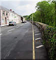
Riverside wall, Heol Giedd, Ystradgynlais
Above the River Tawe.
Image: © Jaggery
Taken: 20 May 2016
0.05 miles