IMAGES TAKEN NEAR TO
Rhydarw Terrace, SWANSEA, SA9 1FB
Introduction
This page details the photographs taken nearby to Rhydarw Terrace, SA9 1FB by members of the Geograph project.
The Geograph project started in 2005 with the aim of publishing, organising and preserving representative images for every square kilometre of Great Britain, Ireland and the Isle of Man.

There are currently over 7.5m images from over14,400 individuals and you can help contribute to the project by visiting https://www.geograph.org.uk
Image Map
Images are licensed for reuse under creativecommons.org/licenses/by-sa/2.0
Notes
- Clicking on the map will re-center to the selected point.
- The higher the marker number, the further away the image location is from the centre of the postcode.
Image Listing (24 Images Found)
Images are licensed for reuse under creativecommons.org/licenses/by-sa/2.0
Image
Details
Distance
1
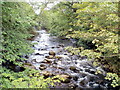
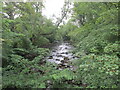
River Tawe flows towards Pont rhyd-arw, Penycae
View from the bridge http://www.geograph.org.uk/photo/2569360 carrying a minor road. Pont rhyd-arw is Welsh for 'rough ford bridge'. Judging by this view of the rocky Tawe, any ford in this area would indeed have been rough.
Image: © Jaggery
Taken: 21 Aug 2011
0.02 miles
2
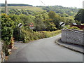
Penycae road to waterfalls
Just behind the camera, a waterfalls sign on the A4067 (Brecon Road) in Penycae points towards this road, but doesn't show how far away the waterfalls are.
The National Speed Limit sign in front of a children's playground sign is incongruous. I expected a 20mph speed limit where children may be walking in the road...
Image: © Jaggery
Taken: 21 Aug 2011
0.02 miles
5
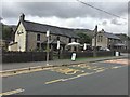
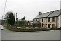
The Pen y Cae Inn
Village pub in Pen y Cae.
Image: © Alan Hughes
Taken: 15 Sep 2018
0.03 miles
6
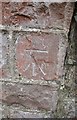
Ordnance Survey Cut Mark
This OS cut mark can be found on the south parapet of the River Tawe Bridge. It marks a point 168.883m above mean sea level.
Image: © Adrian Dust
Taken: 6 May 2016
0.04 miles
7
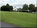
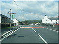
Football pitch, Penycae Primary School
The pitch is located between the school buildings http://www.geograph.org.uk/photo/2569062 beyond the left edge of the view, and Brecon Road (A4067). At the far end of the pitch is the village pub. http://www.geograph.org.uk/photo/2569189
Image: © Jaggery
Taken: 21 Aug 2011
0.05 miles
8
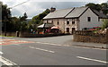
Pen-y-cae Inn, Penycae
The village pub, on the west side of Brecon Road (A4067), was named 2009 Pub of the Year by the Morning Advertiser, the UK's weekly pub trade publication.
The signs outside the pub describe the Pen-y-cae Inn as a 'country pub and restaurant'
Image: © Jaggery
Taken: 21 Aug 2011
0.05 miles
9
River at Pen y Cae.
A peaceful spot.
Image: © steven ruffles
Taken: 28 Jul 2022
0.05 miles
10
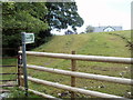
Public footpath from Pont Rhyd-arw, Penycae
A rough track heads away from a bridge, Pont Rhyd-arw http://www.geograph.org.uk/photo/2569360 across the River Tawe.
Image: © Jaggery
Taken: 21 Aug 2011
0.05 miles