IMAGES TAKEN NEAR TO
Spencer Terrace, SWANSEA, SA9 1EG
Introduction
This page details the photographs taken nearby to Spencer Terrace, SA9 1EG by members of the Geograph project.
The Geograph project started in 2005 with the aim of publishing, organising and preserving representative images for every square kilometre of Great Britain, Ireland and the Isle of Man.

There are currently over 7.5m images from over14,400 individuals and you can help contribute to the project by visiting https://www.geograph.org.uk
Image Map
Images are licensed for reuse under creativecommons.org/licenses/by-sa/2.0
Notes
- Clicking on the map will re-center to the selected point.
- The higher the marker number, the further away the image location is from the centre of the postcode.
Image Listing (4 Images Found)
Images are licensed for reuse under creativecommons.org/licenses/by-sa/2.0
Image
Details
Distance
1
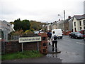
Cwm Twrch Isaf
Cerddwyr yn cyrraedd pentref Cwm Twrch Isaf.
Walkers arriving at the village of Cwm Twrch Isaf [trans. lower boar [river] valley]
Image: © Alan Richards
Taken: 7 Nov 2004
0.12 miles
2
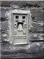
Ordnance Survey Flush Bracket (S6502)
This OS Flush Bracket can be found on a wall to the NE of the road. It marks a point 77.306m above mean sea level.
Image: © Adrian Dust
Taken: 29 Aug 2013
0.12 miles
3
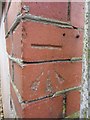
Ordnance Survey Cut Mark
This OS cut mark can be found on the front of No48 Cwmphil Rd. It marks a point 86.025m above mean sea level.
Image: © Adrian Dust
Taken: 15 Aug 2013
0.14 miles
4
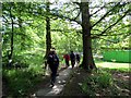
Llwybr Gurnos Path
Cerddwyr yn dilyn llwybr cyhoeddus i gyfeiriad Gorof.
Walkers following a public footpath in the direction of Gorof.
Image: © Alan Richards
Taken: 7 Jun 2015
0.14 miles