IMAGES TAKEN NEAR TO
Ynyscedwyn Road, SWANSEA, SA9 1BH
Introduction
This page details the photographs taken nearby to Ynyscedwyn Road, SA9 1BH by members of the Geograph project.
The Geograph project started in 2005 with the aim of publishing, organising and preserving representative images for every square kilometre of Great Britain, Ireland and the Isle of Man.

There are currently over 7.5m images from over14,400 individuals and you can help contribute to the project by visiting https://www.geograph.org.uk
Image Map
Images are licensed for reuse under creativecommons.org/licenses/by-sa/2.0
Notes
- Clicking on the map will re-center to the selected point.
- The higher the marker number, the further away the image location is from the centre of the postcode.
Image Listing (4 Images Found)
Images are licensed for reuse under creativecommons.org/licenses/by-sa/2.0
Image
Details
Distance
1
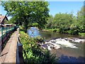
Llwybr glanafon. / Riverside path
Llwybr ar lan Afon Tawe Tawe yn Ystradgynlais.
Riverside path along the Tawe River in Ystradgynlais.
Image: © Alan Richards
Taken: 7 Jun 2015
0.12 miles
2
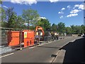
Roadworks in Ystradgynlais
Roadworks on College Row, Ystradgynlais.
Image: © Alan Hughes
Taken: 15 May 2018
0.23 miles
3
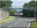
Footbridge over the A4067 at Ystradgynlais
Image: © Peter Robinson
Taken: 26 Jul 2012
0.25 miles
4
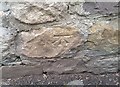
Ordnance Survey Cut Mark
This OS cut mark can be found on the wall of No11 Gorof Road. It marks a point 83.486m above mean sea level.
Image: © Adrian Dust
Taken: 3 May 2020
0.25 miles