IMAGES TAKEN NEAR TO
Gough Avenue, SWANSEA, SA9 1AW
Introduction
This page details the photographs taken nearby to Gough Avenue, SA9 1AW by members of the Geograph project.
The Geograph project started in 2005 with the aim of publishing, organising and preserving representative images for every square kilometre of Great Britain, Ireland and the Isle of Man.

There are currently over 7.5m images from over14,400 individuals and you can help contribute to the project by visiting https://www.geograph.org.uk
Image Map
Images are licensed for reuse under creativecommons.org/licenses/by-sa/2.0
Notes
- Clicking on the map will re-center to the selected point.
- The higher the marker number, the further away the image location is from the centre of the postcode.
Image Listing (13 Images Found)
Images are licensed for reuse under creativecommons.org/licenses/by-sa/2.0
Image
Details
Distance
1
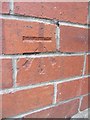
Ordnance Survey Cut Mark
This OS cut mark can be found on the side of NO8 Croesffyrdd. It marks a point 68.120m above mean sea level.
Image: © Adrian Dust
Taken: 15 Aug 2013
0.03 miles
2
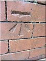
Ordnance Survey Cut Mark
This OS cut mark can be found on the corner of J Evans Cycles, No112 Wind Street. It marks a point 67.839m above mean sea level.
Image: © Adrian Dust
Taken: 29 Mar 2014
0.08 miles
3
Ysgol Bro Tawe
Croeso - welcome to Ysgol Bro Tawe.
Image: © Alan Hughes
Taken: 14 Jul 2019
0.09 miles
4
Bridge over the River Tawe to Varteg Hill
Image: © Peter Robinson
Taken: 20 Jul 2012
0.17 miles
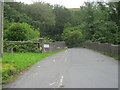
5
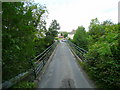
Glan-rhyd Bridge
Taking the minor road from the Dulais over the Tawe.
Image: © Jonathan Billinger
Taken: 8 Aug 2008
0.17 miles
6
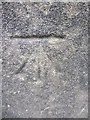
Ordnance Survey Cut Mark
This OS cut mark can be found on the west parapet of Glan Rhyd Bridge. It marks a point 66.839m above mean sea level.
Image: © Adrian Dust
Taken: 29 Mar 2014
0.17 miles
7
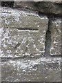
Ordnance Survey Cut Mark
This OS cut mark can be found on the wall to the NW side of the road. It marks a point 71.509m above mean sea level.
Image: © Adrian Dust
Taken: 15 Aug 2013
0.17 miles
8
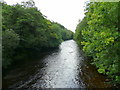
River Tawe - downstream
View south-west from the Glan-rhyd Bridge.
Image: © Jonathan Billinger
Taken: 8 Aug 2008
0.20 miles
9
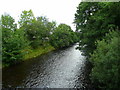
River Tawe - upstream
View north-east from Glan-rhyd Bridge
Image: © Jonathan Billinger
Taken: 8 Aug 2008
0.21 miles
10
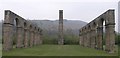
Ynyscedwyn iron works
With the many coal mines in the surrounding area, it was only natural for the heavy industry of metal working to go hand in hand. Here we see the remains of the victorian Ynyscedwyn iron works, which made use of the revolutionary hot blast process.
The arches and chimney stack are all that remain today of a large factory that sprawled across this area.
Image: © Hywel Williams
Taken: 13 Apr 2007
0.22 miles