IMAGES TAKEN NEAR TO
Penlan Road, SWANSEA, SA8 4RP
Introduction
This page details the photographs taken nearby to Penlan Road, SA8 4RP by members of the Geograph project.
The Geograph project started in 2005 with the aim of publishing, organising and preserving representative images for every square kilometre of Great Britain, Ireland and the Isle of Man.

There are currently over 7.5m images from over14,400 individuals and you can help contribute to the project by visiting https://www.geograph.org.uk
Image Map
Images are licensed for reuse under creativecommons.org/licenses/by-sa/2.0
Notes
- Clicking on the map will re-center to the selected point.
- The higher the marker number, the further away the image location is from the centre of the postcode.
Image Listing (5 Images Found)
Images are licensed for reuse under creativecommons.org/licenses/by-sa/2.0
Image
Details
Distance
1
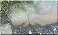
Ordnance Survey Pivot
This OS pivot can be found at the stone east side of the road. It marks a point 148.280m above mean sea level.
Image: © Adrian Dust
Taken: 13 Jun 2021
0.11 miles
2
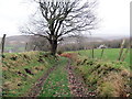
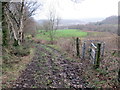
Llwybr i Heol Penlan / Path to Penlan Road
Llwybr cyhoeddus yn mynd i lawr y waered i gyfeiriad Heol Penlan.
A public footpath descending in the direction of Penlan (trans. hill top) Road.
Image: © Alan Richards
Taken: 18 Feb 2020
0.11 miles
3
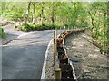
Landslip repair on Gellionnen Road, Rhyd-y-fro
This bank high above a meander of the Upper Clydach River has been shored up with metal girders.
The kerb stones and ornamental gravel are far more extravagant than the simple tarmac on any of the other country roads around here.
Image: © Nigel Davies
Taken: 30 May 2010
0.22 miles
4
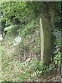
Stone Gatepost
This stone gatepost can be found to the SE of the road. It has an OS Cut Mark on the SW face which marks a point 182.7063m above mean sea level.
Image: © Adrian Dust
Taken: 27 Jul 2013
0.23 miles
5
Llwybr ger Heol Ddu Newydd / Path near Heol Ddu Newydd
Llwybr cyhoeddus yn gadael trac ger Ffarm Heol Ddu Newydd, Ar adeg ysgrifennu hwn mae'r llwybr wedi ei rwystro.
A public footpath leaving a track near Heol Ddu Newydd Farm (trans. new black road). At the time of writing the path is obstructed.
Image: © Alan Richards
Taken: 18 Feb 2020
0.23 miles