IMAGES TAKEN NEAR TO
Gellionen Road, SWANSEA, SA8 4RN
Introduction
This page details the photographs taken nearby to Gellionen Road, SA8 4RN by members of the Geograph project.
The Geograph project started in 2005 with the aim of publishing, organising and preserving representative images for every square kilometre of Great Britain, Ireland and the Isle of Man.

There are currently over 7.5m images from over14,400 individuals and you can help contribute to the project by visiting https://www.geograph.org.uk
Image Map
Images are licensed for reuse under creativecommons.org/licenses/by-sa/2.0
Notes
- Clicking on the map will re-center to the selected point.
- The higher the marker number, the further away the image location is from the centre of the postcode.
Image Listing (3 Images Found)
Images are licensed for reuse under creativecommons.org/licenses/by-sa/2.0
Image
Details
Distance
1
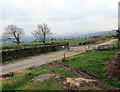
Heol Gellionnen / Gellionnen Road
Llwybr ceffyl yn ymuno a heol Gellionnen.
A bridleway joining Gellionnen Road (trans. ash grove).
Image: © Alan Richards
Taken: 31 Dec 2019
0.15 miles
2
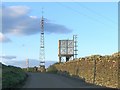
Mast and water tower in hills above Trebanos
These are in a field at the side of the road northeast to Mynydd Gellionen. Trebanos is down in the Swansea valley to the right.
Image: © Nigel Davies
Taken: 29 May 2006
0.20 miles
3
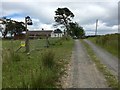
Driveway to Spa House
Perhaps the name 'Spa House' has something to do with the fact that there are several springs in the area, including Ffynnon Wen which has historic religious significance associated with Gellionen Chapel and Llan Eithrim.
Image: © Alan Hughes
Taken: 1 Jul 2017
0.22 miles