IMAGES TAKEN NEAR TO
Tanydarren, SWANSEA, SA8 4QR
Introduction
This page details the photographs taken nearby to Tanydarren, SA8 4QR by members of the Geograph project.
The Geograph project started in 2005 with the aim of publishing, organising and preserving representative images for every square kilometre of Great Britain, Ireland and the Isle of Man.

There are currently over 7.5m images from over14,400 individuals and you can help contribute to the project by visiting https://www.geograph.org.uk
Image Map (Loading...)


Getting Data...Please wait
Leaflet Map data © OpenStreetMap
Images are licensed for reuse under creativecommons.org/licenses/by-sa/2.0
Notes
- Clicking on the map will re-center to the selected point.
- The higher the marker number, the further away the image location is from the centre of the postcode.
Image Listing (11 Images Found)
Images are licensed for reuse under creativecommons.org/licenses/by-sa/2.0
Image
Details
Distance
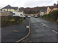
3
Cilmaengwyn Road, Cilmaengwyn
The main road through the village of Cilmaengwyn, NE of Pontardawe in Neath Port Talbot County Borough.
Image: © Jaggery
Taken: 1 Mar 2014
0.14 miles
4
Swansea Canal Lockgate
Swansea Canal lockgate at Cilmaengwyn (Swansea Canal Walk).
Image: © Tawe Tours
Taken: Unknown
0.14 miles
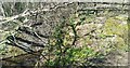
5
Camlas Abertawe / Swansea Canal
Gweddillion camlas. Fe'i hadeiladwyd rhwng 1794-1798 gan y Swansea Canal Navigation Company er cludo glo i lawr o Gwm Tawe Uchaf i'r dociau yn Abertawe.
Remains of a canal. Built by The Swansea Canal Navigation Company between 1794-1798 it carried coal down from the Upper Swansea Valley to the docks in Swansea
Image: © Alan Richards
Taken: 7 Jul 2021
0.15 miles
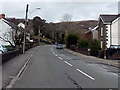
6
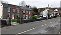
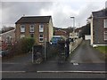
Cilmaengwyn Road houses, Cilmaengwyn
Looking north along Cilmaengwyn Road.
Image: © Jaggery
Taken: 1 Mar 2014
0.18 miles
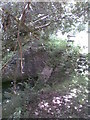
7
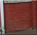
Ordnance Survey Cut Mark
This OS cut mark can be found on No21 Maengwyn. It marks a point 101.602m above mean sea level.
Image: © Adrian Dust
Taken: 28 Apr 2020
0.19 miles
8
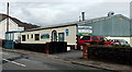
Carters garage, Cilmaengwyn
MoT and vehicle repair centre at 40 Cilmaengwyn Road.
Image: © Jaggery
Taken: 1 Mar 2014
0.23 miles
9
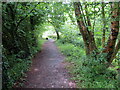
Footpath through houses
Public footpath through a housing estate in Cilmaengwyn.
Image: © Alan Hughes
Taken: 13 Nov 2018
0.24 miles
10
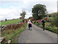
Uwchben Cilmaengwyn Isaf / Above Cilmaengwyn Isaf
Cerddwyr yn dilyn heol fach uwchben Ffarm Cilmaengwyn Isaf.
Walkers following a minor road above Cilmaengwyn Isaf Farm (trans. nook of the white stone lower farm).
Image: © Alan Richards
Taken: 21 Oct 2018
0.24 miles