IMAGES TAKEN NEAR TO
Llanguicke Road, SWANSEA, SA8 4PL
Introduction
This page details the photographs taken nearby to Llanguicke Road, SA8 4PL by members of the Geograph project.
The Geograph project started in 2005 with the aim of publishing, organising and preserving representative images for every square kilometre of Great Britain, Ireland and the Isle of Man.

There are currently over 7.5m images from over14,400 individuals and you can help contribute to the project by visiting https://www.geograph.org.uk
Image Map (Loading...)


Getting Data...Please wait
Leaflet Map data © OpenStreetMap
Images are licensed for reuse under creativecommons.org/licenses/by-sa/2.0
Notes
- Clicking on the map will re-center to the selected point.
- The higher the marker number, the further away the image location is from the centre of the postcode.
Image Listing (13 Images Found)
Images are licensed for reuse under creativecommons.org/licenses/by-sa/2.0
Image
Details
Distance
1
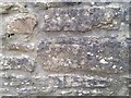
Ordnance Survey Cut Mark
This OS cut mark can be found on Brook Cottage, Church Road. It marks a point 68.739m above mean sea level.
Image: © Adrian Dust
Taken: 4 Apr 2020
0.19 miles
2
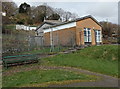
Ynysmeudwy Community Hall
Set back from Old Road, viewed from Ynysmeudwy Park. http://www.geograph.org.uk/photo/4007547
Image: © Jaggery
Taken: 1 Mar 2014
0.21 miles
3
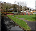
Ynysmeudwy Park
A small public park on the north side of Old Road, Ynysmeudwy.
Image: © Jaggery
Taken: 1 Mar 2014
0.21 miles
4
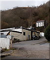
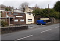
SW Car Body Repairs, Ynysmeudwy
Set back 70 metres from the B4603 New Road.
Image: © Jaggery
Taken: 1 Mar 2014
0.21 miles
5
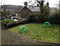
Picnic area in Ynysmeudwy Park
A small picnic area in a small public park on the north side of Old Road, Ynysmeudwy.
Image: © Jaggery
Taken: 1 Mar 2014
0.22 miles
6
Tawe Associates, Ynysmeudwy
Independent financial advisers in New Road, opposite Markwrights Ynysmeudwy Stores. http://www.geograph.org.uk/photo/3871556
Image: © Jaggery
Taken: 1 Mar 2014
0.23 miles
7
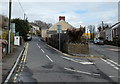
Traffic calming along the B4603 in Ynysmeudwy
A triangular base topped with two metal posts narrows the roadway to less than the width of two standard cars. Vehicles travelling away from the camera have priority over oncoming vehicles.
Image: © Jaggery
Taken: 1 Mar 2014
0.23 miles
8
Old and New in Ynysmeudwy
Old Road is on the left, New Road on the right. Old Road rejoins New Road 400 metres ahead.
Image: © Jaggery
Taken: 1 Mar 2014
0.24 miles
9
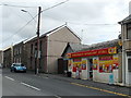
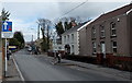
Markwrights Ynysmeudwy Stores
Convenience store at 57 New Road in Ynysmeudwy, a village NE of Pontardawe.
Image: © Jaggery
Taken: 1 Mar 2014
0.24 miles
10
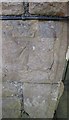
Ordnance Survey Cut Mark
This OS cut mark can be found on No37 New Road. It marks a point 55.928m above mean sea level.
Image: © Adrian Dust
Taken: 13 Jul 2016
0.24 miles