IMAGES TAKEN NEAR TO
East Crossways, SWANSEA, SA8 4NJ
Introduction
This page details the photographs taken nearby to East Crossways, SA8 4NJ by members of the Geograph project.
The Geograph project started in 2005 with the aim of publishing, organising and preserving representative images for every square kilometre of Great Britain, Ireland and the Isle of Man.

There are currently over 7.5m images from over14,400 individuals and you can help contribute to the project by visiting https://www.geograph.org.uk
Image Map
Images are licensed for reuse under creativecommons.org/licenses/by-sa/2.0
Notes
- Clicking on the map will re-center to the selected point.
- The higher the marker number, the further away the image location is from the centre of the postcode.
Image Listing (26 Images Found)
Images are licensed for reuse under creativecommons.org/licenses/by-sa/2.0
Image
Details
Distance
1
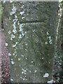
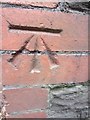
Ordnance Survey Cut Mark
This OS Cut Mark can be found on a stone gate post on the footpath that runs through the woods below the golf course. It marks a point 118.1252m above mean sea level.
Image: © Adrian Dust
Taken: 13 Jul 2013
0.10 miles
2
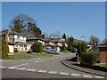
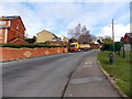
Bryn Derwen, Pontardawe
One of the more recently developed residential roads on the north side of Pontardawe
Image: © Kevin Flynn
Taken: 4 Apr 2007
0.15 miles
3
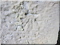
Ordnance Survey Cut Mark
This OS Cut Mark can be found on the front NE angle of a farm building conversion. Once Alltacham Farm. It marks a point 107.6859m above mean sea level.
Image: © Adrian Dust
Taken: 13 Jul 2013
0.16 miles
4
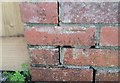
Ordnance Survey Cut Mark
This OS pivot can be found on No26 Cefnllan Road. It marks a point 110.722m above mean sea level.
Image: © Adrian Dust
Taken: 14 Apr 2020
0.17 miles
5
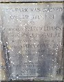
Commemorative Stone Plaque
This Stone Plaque can be found on the gatepost at the entrance to the King George V Memorial Park.
Image: © Adrian Dust
Taken: 13 Apr 2020
0.17 miles
6
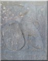
Stone Plaque
This Stone Plaque can be found on the gatepost at the entrance to the King George V Memorial Park.
Image: © Adrian Dust
Taken: 13 Apr 2020
0.17 miles
7
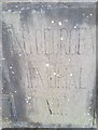
Stone Plaque
This Stone Plaque can be found on the gatepost at the entrance to the King George V Memorial Park.
Image: © Adrian Dust
Taken: 13 Apr 2020
0.17 miles
8
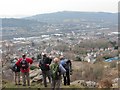
Trem Pontardawe View
Cerddwyr yn edrych dros Pontardawe o Barley Hill (Coedalltacham). Islaw y safai'r ysgol ramadeg.
Walkers looking across Pontardawe from Barley Hill (Coedallacham). Below is the site of the former grammar school.
Image: © Alan Richards
Taken: 7 Apr 2013
0.19 miles
9
Ordnance Survey Cut Mark
This OS Cut Mark can be found on Glynteg Cottage to the SW side of the road. It marks a point 76.6458m above mean sea level.
Image: © Adrian Dust
Taken: 18 Jun 2013
0.19 miles
10
Allt-y-cham Drive, Pontardawe
This part of Allt-y-cham Drive is between Ffordd Bryneulog and Hopkin Street.
The lorry is part of the Nolan Transport fleet.
Image: © Jaggery
Taken: 1 Mar 2014
0.20 miles