IMAGES TAKEN NEAR TO
James Street, SWANSEA, SA8 4LR
Introduction
This page details the photographs taken nearby to James Street, SA8 4LR by members of the Geograph project.
The Geograph project started in 2005 with the aim of publishing, organising and preserving representative images for every square kilometre of Great Britain, Ireland and the Isle of Man.

There are currently over 7.5m images from over14,400 individuals and you can help contribute to the project by visiting https://www.geograph.org.uk
Image Map (Loading...)


Getting Data...Please wait
Leaflet Map data © OpenStreetMap
Images are licensed for reuse under creativecommons.org/licenses/by-sa/2.0
Notes
- Clicking on the map will re-center to the selected point.
- The higher the marker number, the further away the image location is from the centre of the postcode.
Image Listing (122 Images Found)
Images are licensed for reuse under creativecommons.org/licenses/by-sa/2.0
Image
Details
Distance
1
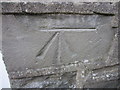
Ordnance Survey Cut Mark
This OS Cut Mark can be found on the front of No54 James Street. It marks a point 57.6011m above mean sea level.
Image: © Adrian Dust
Taken: 13 Jul 2013
0.04 miles
2
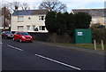
James Street Combined Sewer Overflow, Pontardawe
The dark green box on the right is Welsh Water Asset 72275.
Image: © Jaggery
Taken: 1 Mar 2014
0.04 miles
3
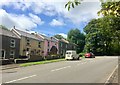
James Street, Pontardawe
Terraced houses in James Street.
Image: © Alan Hughes
Taken: 15 Aug 2019
0.05 miles
4
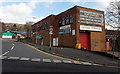
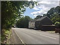
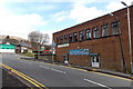
Artizan in Pontardawe
Window and conservatory centre on the corner of James Street and Allt-y-cham Drive.
Pontardawe Ambulance Station http://www.geograph.org.uk/photo/3873940 is on the left. A road sign on the right tells drivers to keep in low gear on the descent of the A474 James Street.
Image: © Jaggery
Taken: 1 Mar 2014
0.06 miles
5
James Street
Houses in James Street, Pontardawe.
Image: © Alan Hughes
Taken: 15 Aug 2019
0.06 miles
6
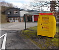
Yellow charity bin outside Pontardawe Fire Station
Located at the entrance to the station, http://www.geograph.org.uk/photo/3873920 the bin is for donations to The Fire Fighters Charity.
Image: © Jaggery
Taken: 1 Mar 2014
0.06 miles
7
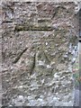
Ordnance Survey Cut Mark
This OS cut mark can be found on the gatepost of All Saints Church. It marks a point 67.087m above mean sea level. http://www.geograph.org.uk/photo/3612532
Image: © Adrian Dust
Taken: 20 Aug 2013
0.06 miles
8
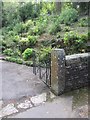
All Saints Gatepost
There is a Ordnance Survey cut mark on the gatepost. http://www.geograph.org.uk/photo/3612526
Image: © Adrian Dust
Taken: 20 Aug 2013
0.06 miles
9
Harmony in Pontardawe
This is the Allt-y-cham Drive side of the UPVC windows & doors installations business located in the Fitness Studio, Church Street. The Ambulance Station http://www.geograph.org.uk/photo/3873940 is on the left.
Image: © Jaggery
Taken: 1 Mar 2014
0.06 miles
10
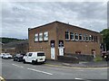
Bodybuilding Hardcore Gym
Formerly the Pavilion Cinema.
See also https://coflein.gov.uk/en/site/416827/?term=Pontardawe%20
Image: © Alan Hughes
Taken: 3 Jul 2022
0.06 miles