IMAGES TAKEN NEAR TO
Heol Y Llwynau, SWANSEA, SA8 4DH
Introduction
This page details the photographs taken nearby to Heol Y Llwynau, SA8 4DH by members of the Geograph project.
The Geograph project started in 2005 with the aim of publishing, organising and preserving representative images for every square kilometre of Great Britain, Ireland and the Isle of Man.

There are currently over 7.5m images from over14,400 individuals and you can help contribute to the project by visiting https://www.geograph.org.uk
Image Map
Images are licensed for reuse under creativecommons.org/licenses/by-sa/2.0
Notes
- Clicking on the map will re-center to the selected point.
- The higher the marker number, the further away the image location is from the centre of the postcode.
Image Listing (4 Images Found)
Images are licensed for reuse under creativecommons.org/licenses/by-sa/2.0
Image
Details
Distance
1
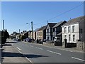
Swansea Road, Trebanos
Housing in Trebanos.
Image: © Alan Hughes
Taken: 26 Mar 2020
0.06 miles
2
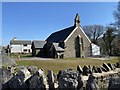
St Michael?s Church, Trebanos
Parish church of St Michael.
Image: © Alan Hughes
Taken: 26 Mar 2020
0.10 miles
3
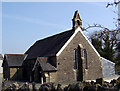
St Michael's Church, Trebanos
Saint Michael and All Angels Church, Swansea Road, Trebanos, consecrated c. 1894.
Image: © Kevin Flynn
Taken: 21 Mar 2009
0.12 miles
4
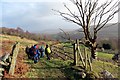
Llwybr ceffyl Trebannws bridleway
Hen heol sy'n cysylltu pentre Trebannws ag ucheldir a elwir mynydd Gellionnen. Mae'r ffordd eisioes wedi ei hisraddio i lwybr ceffyl.
A thoroughfare linking the village of Trebanos with an upland area known as Mynydd Gellionnen (trans. ashgrove). The road has long been downgraded to a bridleway.
Image: © Alan Richards
Taken: 26 Jan 2014
0.23 miles