IMAGES TAKEN NEAR TO
Clos Nant Ddu, SWANSEA, SA8 4BW
Introduction
This page details the photographs taken nearby to Clos Nant Ddu, SA8 4BW by members of the Geograph project.
The Geograph project started in 2005 with the aim of publishing, organising and preserving representative images for every square kilometre of Great Britain, Ireland and the Isle of Man.

There are currently over 7.5m images from over14,400 individuals and you can help contribute to the project by visiting https://www.geograph.org.uk
Image Map (Loading...)


Getting Data...Please wait
Leaflet Map data © OpenStreetMap
Images are licensed for reuse under creativecommons.org/licenses/by-sa/2.0
Notes
- Clicking on the map will re-center to the selected point.
- The higher the marker number, the further away the image location is from the centre of the postcode.
Image Listing (47 Images Found)
Images are licensed for reuse under creativecommons.org/licenses/by-sa/2.0
Image
Details
Distance
1
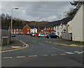
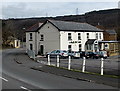
Clos Nant Ddu, Ynysmeudwy
Recently-built houses in a cul-de-sac on the north side of the B4603 Ynysmeudwy Road.
Image: © Jaggery
Taken: 1 Mar 2014
0.02 miles
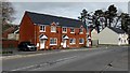
2
Recently-built semis in Ynysmeudwy
Viewed across the B4603 Ynysmeudwy Road. The two semi-detached houses on the left occupy the site of a shabby derelict shop shown on a Google Earth Street View taken in October 2008.
Image: © Jaggery
Taken: 1 Mar 2014
0.04 miles
3
Ynysmeudwy Road houses, Ynysmeudwy
Recently-built houses alongside the B4603 Ynysmeudwy Road. The left turn is for Clos Nant Ddu. http://www.geograph.org.uk/photo/3870888
Image: © Jaggery
Taken: 1 Mar 2014
0.04 miles
4
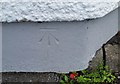
Ordnance Survey Cut Mark
This OS cut mark can be found on the NE face of the Ynysmeudwy Arms. It marks a point 46.055m above mean sea level.
Image: © Adrian Dust
Taken: 25 Aug 2018
0.05 miles
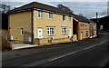
5
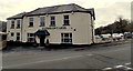
North side of the Ynysmeudwy Arms, Ynysmeudwy
Viewed across the B4603 Ynysmeudwy Road.
Image: © Jaggery
Taken: 1 Mar 2014
0.05 miles
6
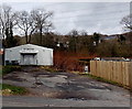
Ynysmeudwy Boys & Girls Club
Set back 25 metres from the north side of the B4603 Ynysmeudwy Road.
Image: © Jaggery
Taken: 1 Mar 2014
0.05 miles
7
Ynysmeudwy Arms, Ynysmeudwy
Viewed across the B4603 Ynysmeudwy Road NE of Pontardawe.
Image: © Jaggery
Taken: 1 Mar 2014
0.05 miles
8
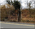
Steps up from Ynysmeudwy Road, Ynysmeudwy
The steps lead to Bethesda Road.
Image: © Jaggery
Taken: 1 Mar 2014
0.05 miles
9
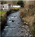
Cwm Du in Ynysmeudwy
The stream Cwm Du flows south towards the camera at the edge of the B4603 Ynysmeudwy Road.
Image: © Jaggery
Taken: 1 Mar 2014
0.07 miles
10
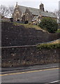
Hillside church in Ynysmeudwy
St Mary's Church is located above the B4603 Ynysmeudwy Road.
The church opened for worship in 1913 (or 1914 - sources differ).
Its status in this early March 2014 view was unclear to this contributor.
Temporary fencing blocks off the church entrance seen here. http://www.geograph.org.uk/photo/4008025
Image: © Jaggery
Taken: 1 Mar 2014
0.08 miles