IMAGES TAKEN NEAR TO
The Drive, SWANSEA, SA8 4BB
Introduction
This page details the photographs taken nearby to The Drive, SA8 4BB by members of the Geograph project.
The Geograph project started in 2005 with the aim of publishing, organising and preserving representative images for every square kilometre of Great Britain, Ireland and the Isle of Man.

There are currently over 7.5m images from over14,400 individuals and you can help contribute to the project by visiting https://www.geograph.org.uk
Image Map (Loading...)


Getting Data...Please wait
Leaflet Map data © OpenStreetMap
Images are licensed for reuse under creativecommons.org/licenses/by-sa/2.0
Notes
- Clicking on the map will re-center to the selected point.
- The higher the marker number, the further away the image location is from the centre of the postcode.
Image Listing (12 Images Found)
Images are licensed for reuse under creativecommons.org/licenses/by-sa/2.0
Image
Details
Distance
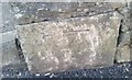
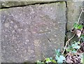
1
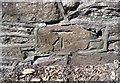
Ordnance Survey Cut Mark
This OS cut mark can be found on the boundary wall west side of Graig Road. It marks a point 75.389m above mean sea level.
Image: © Adrian Dust
Taken: 15 Apr 2020
0.04 miles
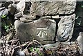
2
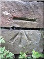
Ordnance Survey Cut Mark
This OS cut mark can be found on a stone wall at the junction of road and track. It marks a point 60.6826m above mean sea level.
Image: © Adrian Dust
Taken: 20 Aug 2013
0.06 miles
3
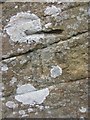
Ordnance Survey Cut Mark
This OS cut mark can be found on a rock at the road junction. It marks a point 85.1032m above mean sea level. http://www.geograph.org.uk/photo/3612574
Image: © Adrian Dust
Taken: 20 Aug 2013
0.08 miles
4
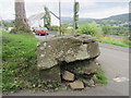
Rock at Junction
Graffiti covered rock at road junction. It also has an Ordnance Survey cut mark on the west face. http://www.geograph.org.uk/photo/3612567
Image: © Adrian Dust
Taken: 20 Aug 2013
0.08 miles
5
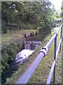
Swansea Canal Lockgate
A ruined lockgate on the Swansea Canal (Swansea Canal Walk).
Image: © Tawe Tours
Taken: Unknown
0.14 miles
6
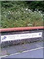
Swansea Canal (Trebanos)
Swansea Canal sign at Trebanos (Swansea Canal Walk).
Image: © Tawe Tours
Taken: Unknown
0.15 miles
7
Ordnance Survey Cut Mark
This OS cut mark can be found on the wall of No102 Pontardawe Road. It marks a point 38.636m above mean sea level.
Image: © Adrian Dust
Taken: 15 Apr 2020
0.16 miles
8
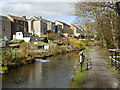
The Swansea Canal at Trebanos
A short aqueduct carries the canal over a sidestream flowing from northwest (left) to southeast (right) into the River Tawe here. The houses in this view front the B4603, Swansea Road.
Image: © Kevin Flynn
Taken: 16 Mar 2009
0.16 miles
9
Ordnance Survey Cut Mark
This OS cut mark can be found on the west side of the Railway Bridge. It marks a point 55.666m above mean sea level.
Image: © Adrian Dust
Taken: 15 Apr 2020
0.17 miles
10
Ordnance Survey Cut Mark
This OS cut mark can be found on the ruin west side of Graig Road. It marks a point 111.505m above mean sea level.
Image: © Adrian Dust
Taken: 15 Apr 2020
0.18 miles