IMAGES TAKEN NEAR TO
Pontardawe, SWANSEA, SA8 3JJ
Introduction
This page details the photographs taken nearby to SA8 3JJ by members of the Geograph project.
The Geograph project started in 2005 with the aim of publishing, organising and preserving representative images for every square kilometre of Great Britain, Ireland and the Isle of Man.

There are currently over 7.5m images from over14,400 individuals and you can help contribute to the project by visiting https://www.geograph.org.uk
Image Map
Images are licensed for reuse under creativecommons.org/licenses/by-sa/2.0
Notes
- Clicking on the map will re-center to the selected point.
- The higher the marker number, the further away the image location is from the centre of the postcode.
Image Listing (5 Images Found)
Images are licensed for reuse under creativecommons.org/licenses/by-sa/2.0
Image
Details
Distance
1
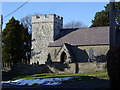
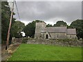
Cilybebyll Church
St John the Evangelist's church at Cilybebyll (the Roman "retreat of the tents").
Image: © Kevin Flynn
Taken: 3 Mar 2006
0.11 miles
2
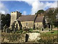
St John's Church
Parish church of St John, Cilybebyll.
Image: © Alan Hughes
Taken: 13 Nov 2018
0.16 miles
3
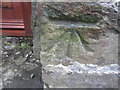
Ordnance Survey Cut Mark
This OS cut mark can be found on the tower of St John's Church. It marks a point 147.264m above mean sea level. http://www.geograph.org.uk/photo/3830214
Image: © Adrian Dust
Taken: 30 Jan 2014
0.17 miles
4
St John's Church
There is an OS cut mark on the tower. http://www.geograph.org.uk/photo/3830210
Image: © Adrian Dust
Taken: 30 Jan 2014
0.17 miles
5
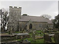
Cilybebyll Church
Cilybebyll Church Saint John the Evangelist, Church Road, Cilybebyll. Formerly in West Glamorgan, now Neath Port Talbot.
Image: © Emma M Baker
Taken: 23 Aug 2022
0.18 miles