IMAGES TAKEN NEAR TO
Waun Daniel, SWANSEA, SA8 3HR
Introduction
This page details the photographs taken nearby to Waun Daniel, SA8 3HR by members of the Geograph project.
The Geograph project started in 2005 with the aim of publishing, organising and preserving representative images for every square kilometre of Great Britain, Ireland and the Isle of Man.

There are currently over 7.5m images from over14,400 individuals and you can help contribute to the project by visiting https://www.geograph.org.uk
Image Map
Images are licensed for reuse under creativecommons.org/licenses/by-sa/2.0
Notes
- Clicking on the map will re-center to the selected point.
- The higher the marker number, the further away the image location is from the centre of the postcode.
Image Listing (30 Images Found)
Images are licensed for reuse under creativecommons.org/licenses/by-sa/2.0
Image
Details
Distance
1
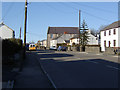
Rhos
Ebenezer Chapel and monkey-puzzle tree at Rhos on the A474 between Neath and Pontardawe. Looking NNW.
Image: © Kevin Flynn
Taken: 3 Mar 2006
0.04 miles
2
Roofer required, Rhos
There are several gaps in the slates on the roof of this Neath Road building.
Image: © Jaggery
Taken: 14 Mar 2014
0.07 miles
3
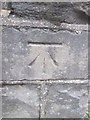
Ordnance Survey Cut Mark
This OS cut mark can be found on the wall of No110 Neath Road. It marks a point 117.208m above mean sea level.
Image: © Adrian Dust
Taken: 15 Mar 2015
0.07 miles
4
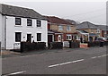
Neath Road houses, Rhos
The white house on the left is White Lodge.
Image: © Jaggery
Taken: 14 Mar 2014
0.08 miles
5
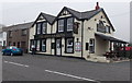
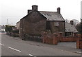
The Smith's Arms, Rhos
Viewed across the A474 Neath Road.
Image: © Jaggery
Taken: 14 Mar 2014
0.08 miles
6
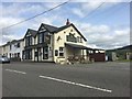
The Smiths Arms
The Smiths Arms, Rhos - on the A474 between Neath and Pontardawe.
Image: © Alan Hughes
Taken: 24 Aug 2017
0.08 miles
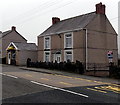
7

Houses on the north side of The Smith's Arms, Rhos
Viewed across the A474 Neath Road looking towards The Smith's Arms http://www.geograph.org.uk/photo/3888307
Image: © Jaggery
Taken: 14 Mar 2014
0.08 miles
8
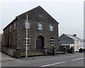
Former Rhos Independent Chapel (Ebenezer)
Viewed across the A474 Neath Road. There are no nameboards here, so it appears that the building is now in residential use. The year 1904 is inscribed on a tablet above the central upper window.
Image: © Jaggery
Taken: 14 Mar 2014
0.09 miles
9
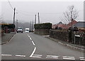
Primrose Lane, Rhos
Looking west across the A474 Neath Road. This was the way to New Primrose Colliery,
which was developed from Primrose Colliery after the disaster of 1853.
The colliery closed in the early 20th century.
Image: © Jaggery
Taken: 14 Mar 2014
0.10 miles
10
Snips in Rhos
Unisex hair salon in the single-storey building on the left, 83A Neath Road.
Image: © Jaggery
Taken: 14 Mar 2014
0.11 miles