IMAGES TAKEN NEAR TO
Primrose Lane, SWANSEA, SA8 3ET
Introduction
This page details the photographs taken nearby to Primrose Lane, SA8 3ET by members of the Geograph project.
The Geograph project started in 2005 with the aim of publishing, organising and preserving representative images for every square kilometre of Great Britain, Ireland and the Isle of Man.

There are currently over 7.5m images from over14,400 individuals and you can help contribute to the project by visiting https://www.geograph.org.uk
Image Map
Images are licensed for reuse under creativecommons.org/licenses/by-sa/2.0
Notes
- Clicking on the map will re-center to the selected point.
- The higher the marker number, the further away the image location is from the centre of the postcode.
Image Listing (4 Images Found)
Images are licensed for reuse under creativecommons.org/licenses/by-sa/2.0
Image
Details
Distance
1
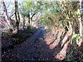
Llwybr Primrose Path
Llwybr cyhoeddus yn arwain o Heol Primrose tuag at Alltwen.
A public footpath heading from Primrose Road towards Alltwen (trans. fairhill).
Image: © Alan Richards
Taken: 29 Dec 2013
0.03 miles
2
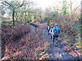
Llwybr Nant y Llechau Path
Cerddwyr yn dilyn llwybr cyhoeddus ar lan Nant y Llechau i gyfeiriad Alltwen.
Walkers following a path on the banks of Nant y Llechau Stream (trans. stone slabs?) in the direction of Alltwen (trans. fairhill).
Image: © Alan Richards
Taken: 29 Dec 2013
0.11 miles
3
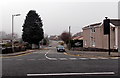
Delffordd, Rhos
Looking WSW along Delffordd across the A474 Neath Road.
Image: © Jaggery
Taken: 14 Mar 2014
0.24 miles
4
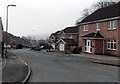
Maes y Cornel, Alltwen
Looking south from Pen yr Alltwen along a residential cul-de-sac.
Image: © Jaggery
Taken: 14 Mar 2014
0.25 miles