IMAGES TAKEN NEAR TO
Tyn Y Cae, SWANSEA, SA8 3DL
Introduction
This page details the photographs taken nearby to Tyn Y Cae, SA8 3DL by members of the Geograph project.
The Geograph project started in 2005 with the aim of publishing, organising and preserving representative images for every square kilometre of Great Britain, Ireland and the Isle of Man.

There are currently over 7.5m images from over14,400 individuals and you can help contribute to the project by visiting https://www.geograph.org.uk
Image Map
Images are licensed for reuse under creativecommons.org/licenses/by-sa/2.0
Notes
- Clicking on the map will re-center to the selected point.
- The higher the marker number, the further away the image location is from the centre of the postcode.
Image Listing (9 Images Found)
Images are licensed for reuse under creativecommons.org/licenses/by-sa/2.0
Image
Details
Distance
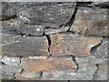
1
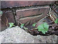
Ordnance Survey Cut Mark
This partially buried OS cut mark can be found on the Electricity Sub-Station to the NE of the footpath. It marks a point 71.8627m above mean sea level.
Image: © Adrian Dust
Taken: 30 Jan 2014
0.10 miles
2
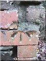
Ordnance Survey Cut Mark
This OS cut mark can be found on a redundant brick gatepost to the SW of the footpath. It marks a point 63.7398m above mean sea level.
Image: © Adrian Dust
Taken: 30 Jan 2014
0.11 miles
3
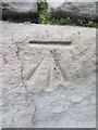
Ordnance Survey Cut Mark
This OS cut mark can be found on the building to the NW of The Triangle on Mount Pleasant. It marks a point 73.5848m above mean sea level.
Image: © Adrian Dust
Taken: 30 Jan 2014
0.14 miles
4
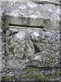
Ordnance Survey Cut Mark
This OS cut mark can be found on Alltwen Chapel. It marks a point 86.0389m above mean sea level.
Image: © Adrian Dust
Taken: 30 Jan 2014
0.14 miles
5
Ordnance Survey Cut Mark
This OS cut mark can be found on the wall of No70 Gwyn Street. It marks a point 53.273m above mean sea level.
Image: © Adrian Dust
Taken: 28 Jun 2023
0.15 miles
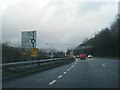
7
Footbridge over the A4067 at Pontardawe
Image: © Peter Robinson
Taken: 26 Jul 2012
0.18 miles
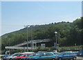
8
Pontardawe
A view of Pontardawe looking north from the footbridge over the A4067. The landmark spire of St Peter's is just left of centre.
Image: © Kevin Flynn
Taken: 3 Mar 2006
0.19 miles
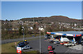
9
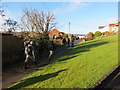
Heol Penygraig Road
Cerddwyr yn dilyn Heol Pen y Graig yn Alltwen.
Walkers following Pen y Graig Road (trans. top of the crag) in Alltwen (trans. fairhill).
Image: © Alan Richards
Taken: 29 Dec 2013
0.20 miles