IMAGES TAKEN NEAR TO
Clos Y Fran, SWANSEA, SA7 9TH
Introduction
This page details the photographs taken nearby to Clos Y Fran, SA7 9TH by members of the Geograph project.
The Geograph project started in 2005 with the aim of publishing, organising and preserving representative images for every square kilometre of Great Britain, Ireland and the Isle of Man.

There are currently over 7.5m images from over14,400 individuals and you can help contribute to the project by visiting https://www.geograph.org.uk
Image Map
Images are licensed for reuse under creativecommons.org/licenses/by-sa/2.0
Notes
- Clicking on the map will re-center to the selected point.
- The higher the marker number, the further away the image location is from the centre of the postcode.
Image Listing (9 Images Found)
Images are licensed for reuse under creativecommons.org/licenses/by-sa/2.0
Image
Details
Distance
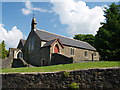
2
Globe Inn
The Globe Inn in the centre of Glais.
Image: © John Phoenix
Taken: 22 Mar 2007
0.07 miles
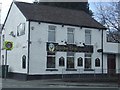
3
The Globe Inn
Public house in Glais on the corner of School Road.
Image: © Alan Hughes
Taken: 7 Oct 2018
0.08 miles
4
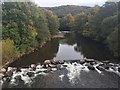
Tawe River
View of the Tawe from the bridge at Glais.
Image: © Alan Hughes
Taken: 7 Oct 2018
0.16 miles
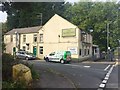
5
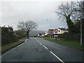
Birchgrove Road at Glais village boundary
Image: © Colin Pyle
Taken: 31 Dec 2012
0.20 miles
6

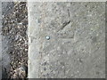
Ordnance Survey Cut Mark
This OS cut mark can be found to the NE of the road on the wall angle. It marks a point 69.985m above mean sea level.
Image: © Adrian Dust
Taken: 15 Mar 2015
0.23 miles
7
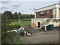
Golf Clubhouse
Mond Valley Golf Clubhouse.
Image: © Alan Hughes
Taken: 7 Oct 2018
0.24 miles
8
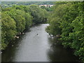
River Tawe, near Glais
Looking upstream, taken from the A4067 bridge.
Image: © Chris Eilbeck
Taken: 1 Jun 2008
0.24 miles
9
Ordnance Survey Rivet
This OS rivet can be found on the roadside wall, west side of Ynys-Y-Mond Road. It marks a point 30.221m above mean sea level.
Image: © Adrian Dust
Taken: 15 Mar 2015
0.24 miles