IMAGES TAKEN NEAR TO
Pantyblawd Road, SWANSEA, SA7 9RN
Introduction
This page details the photographs taken nearby to Pantyblawd Road, SA7 9RN by members of the Geograph project.
The Geograph project started in 2005 with the aim of publishing, organising and preserving representative images for every square kilometre of Great Britain, Ireland and the Isle of Man.

There are currently over 7.5m images from over14,400 individuals and you can help contribute to the project by visiting https://www.geograph.org.uk
Image Map
Images are licensed for reuse under creativecommons.org/licenses/by-sa/2.0
Notes
- Clicking on the map will re-center to the selected point.
- The higher the marker number, the further away the image location is from the centre of the postcode.
Image Listing (19 Images Found)
Images are licensed for reuse under creativecommons.org/licenses/by-sa/2.0
Image
Details
Distance
1
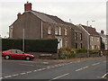
Walters Road houses, Llansamlet, Swansea
The car is parked in Pant y Blawd Road which is where Church Road behind the camera becomes Walters Road ahead.
Image: © Jaggery
Taken: 28 Nov 2013
0.08 miles
2
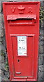
Victorian postbox in a church wall, Llansamlet, Swansea
Located in the Church Road perimeter wall of St Samlet's Church.
The red edge of the postbox is faintly visible here http://www.geograph.org.uk/photo/3804695 (centre left)
Image: © Jaggery
Taken: 28 Nov 2013
0.09 miles
3
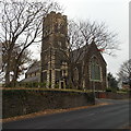
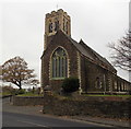
St Samlet's church, Llansamlet, Swansea
Viewed across Church Road.
St Samlet's is in the Church in Wales Parish of Llansamlet in the Diocese of Swansea and Brecon.
Image: © Jaggery
Taken: 28 Nov 2013
0.09 miles
4
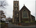
Entrance to St Samlet's church, Llansamlet, Swansea
Viewed across Church Road. St Samlet's is in the Church in Wales Parish of Llansamlet in the Diocese of Swansea and Brecon.
Image: © Jaggery
Taken: 28 Nov 2013
0.09 miles
5
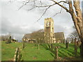
Llansamlet Church
St Samlet (St Samled). Built 1875-79.
Image: © Adrian Dust
Taken: 12 Jan 2012
0.09 miles
6
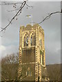
Llansamlet Church Tower
The Ordnance Survey used the tower flagstaff as a 3rd Order Triangulation Point (Intersected Station SN80/T082)
Image: © Adrian Dust
Taken: 12 Jan 2012
0.09 miles
7
NE corner of St Samlet's church, Llansamlet, Swansea
Viewed across Church Road. St Samlet's is in the Church in Wales
Parish of Llansamlet in the Diocese of Swansea and Brecon.
Image: © Jaggery
Taken: 28 Nov 2013
0.09 miles
8
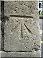
Ordnance Survey Cut Mark
This OS cut mark can be found on the tower of St Samlet's Church. It marks a point 20.321m above mean sea level.
Image: © Adrian Dust
Taken: 6 May 2014
0.09 miles
9
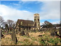
Eglwys Llansamlet / Llansamlet Church
Eglwys y plwyf, Llansamlet. Adeiladwyd yr adeilad presennol yn 1878-79 ar safle yr hen eglwys ac fe ychwanegwyd y twr yn 1914-15.
The parish church of Llansamlet (trans. church of St Samlet). The present edifice was constructed in 1878-79 replacing a much earlier building. The tower was added in 1914-15.
Image: © Alan Richards
Taken: 27 Feb 2017
0.12 miles
10
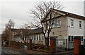
Ysgol Gynradd Gymraeg L?n Las, Llansamlet. Swansea
Welsh-language primary school in Walters Road.
Image: © Jaggery
Taken: 28 Nov 2013
0.13 miles