IMAGES TAKEN NEAR TO
Bethel Road, SWANSEA, SA7 9QP
Introduction
This page details the photographs taken nearby to Bethel Road, SA7 9QP by members of the Geograph project.
The Geograph project started in 2005 with the aim of publishing, organising and preserving representative images for every square kilometre of Great Britain, Ireland and the Isle of Man.

There are currently over 7.5m images from over14,400 individuals and you can help contribute to the project by visiting https://www.geograph.org.uk
Image Map
Images are licensed for reuse under creativecommons.org/licenses/by-sa/2.0
Notes
- Clicking on the map will re-center to the selected point.
- The higher the marker number, the further away the image location is from the centre of the postcode.
Image Listing (16 Images Found)
Images are licensed for reuse under creativecommons.org/licenses/by-sa/2.0
Image
Details
Distance
1
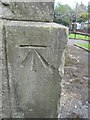
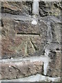
Ordnance Survey Cut Mark
This OS cut mark can be found on the west angle of Bethel Chapel. It marks a point 42.044m above mean sea level.
Image: © Adrian Dust
Taken: 2 Sep 2015
0.04 miles
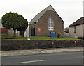
2
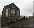
Capel Bethel, Llansamlet
Bethel, Capel yr Annibynnwyr, Llansamlet. Bu aelodau cynnar yr achos hwn yn addoli yn ystod y 18g ar odre Mynydd y Drumau cyn symud i ffermdai agosach megis Talchopa Evan a Thai Eshter. Codwyd y capel cyntaf yn 1818 a'r ail yn 1850. Mae'r addoldy presennol yn dyddio o 1880 ac yn eitedd 900 o bobl. Yn y dyddiau a fu safai'r hen gapeli ar y ffordd fawr i Gastell Nedd.
Bethel Welsh Independent Chapel, Llansamlet. The early worshippers met during the C18 on the foot of Mynydd y Drumau before moving to nearby farmhouses such as Talchopa and Tai Eshter. The first Bethel Chapel was built in 1818 and this was replaced by a new edifice in 1850. The present chapel, which sits 900 people, was constructed in 1880. Interestingly, the road passing the chapel was once the main thoroughfare to Neath.
Image: © Alan Richards
Taken: 15 Mar 2013
0.05 miles
3
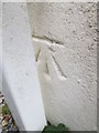
Ordnance Survey Cut Mark
This OS cut mark can be found on No47 Bethel Road, Knutt House Hairdressers. It marks a point 47.110m above mean sea level.
Image: © Adrian Dust
Taken: 2 Sep 2015
0.10 miles
5
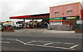
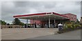
Llansamlet Service Station, Swansea
Texaco filling station and a Londis store viewed across the A48 Peniel Green Road.
Image: © Jaggery
Taken: 28 Nov 2013
0.12 miles
6
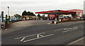
Texaco filling station in Llansamlet, Swansea
Part of Llansamlet Service Station, viewed across the A48 Peniel Green Road.
Image: © Jaggery
Taken: 28 Nov 2013
0.12 miles
7
Ordnance Survey Cut Mark
This OS cut mark can be found on the NE buttress of the railway bridge. It marks a point 31.943m above mean sea level.
Image: © Adrian Dust
Taken: 2 Sep 2015
0.15 miles
8
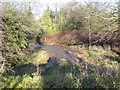
Abandoned road
This is all that remains of a road that used to link Peniel Green with Heol Las in the Llansamlet area. The road was intersected by a new road development Image and this photograph was taken from the same location as that one.
Image: © Hywel Williams
Taken: 16 Dec 2006
0.16 miles
9
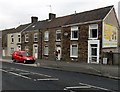
Making a delivery in Llansamlet
The Royal Mail van and postman are outside a Peniel Green Road house.
Image: © Jaggery
Taken: 28 Nov 2013
0.17 miles
10
Peniel Green Congregational Church, Llansamlet, Swansea
Viewed across the A48 Peniel Green Road.
Image: © Jaggery
Taken: 28 Nov 2013
0.17 miles