IMAGES TAKEN NEAR TO
Heol Brithdir, SWANSEA, SA7 9NW
Introduction
This page details the photographs taken nearby to Heol Brithdir, SA7 9NW by members of the Geograph project.
The Geograph project started in 2005 with the aim of publishing, organising and preserving representative images for every square kilometre of Great Britain, Ireland and the Isle of Man.

There are currently over 7.5m images from over14,400 individuals and you can help contribute to the project by visiting https://www.geograph.org.uk
Image Map
Images are licensed for reuse under creativecommons.org/licenses/by-sa/2.0
Notes
- Clicking on the map will re-center to the selected point.
- The higher the marker number, the further away the image location is from the centre of the postcode.
Image Listing (8 Images Found)
Images are licensed for reuse under creativecommons.org/licenses/by-sa/2.0
Image
Details
Distance
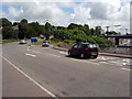
1
Road Junction at Lon Las
Left turning to Peniel Green, straight ahead to Birchgrove.
Image: © Alan Hughes
Taken: 10 Aug 2018
0.14 miles
2
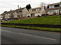
Peniel Green Road houses in Llansamlet Swansea
Viewed across the A4230.
Image: © Jaggery
Taken: 28 Nov 2013
0.22 miles
3
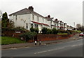
Peniel Green Road houses, Llansamlet Swansea
Viewed across the A4230 on the approach to M4 Motorway junction 44.
Image: © Jaggery
Taken: 28 Nov 2013
0.23 miles
4
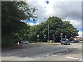
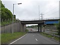
Junction 44 of the M4
The eastbound sliproad from the A48 to the M4 near Birchgrove is unusual in that it peels off the inside of the roundabout that straddles the motorway at this point. Traffic approaching from the B4291 (between the two leftmost lamp posts as seen here) and wishing to join the M4 eastbound has to perform a near 360° circuit of the roundabout.
Image: © Kevin Flynn
Taken: 1 Aug 2008
0.23 miles
5
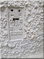
Ordnance Survey Flush Bracket (S1232)
This OS Flush Bracket can be found on No46 Birchgrove Road. It marks a point 71.802m above mean sea level.
Image: © Adrian Dust
Taken: 9 Sep 2015
0.23 miles
6
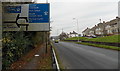
Peniel Green Road approaches a motorway junction in Llansamlet Swansea
Looking NW along the A4230 towards M4 motorway junction 44. This sign shows the motorway options ahead. Another sign http://www.geograph.org.uk/photo/3763502 a short distance ahead shows the other options.
Image: © Jaggery
Taken: 28 Nov 2013
0.24 miles
7
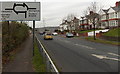
Approaching an unround roundabout in Llansamlet Swansea
Viewed along the A4230 Peniel Green Road. The sign shows the non-motorway options ahead at M4 motorway junction 44. The motorway options are shown on this sign http://www.geograph.org.uk/photo/3763478 behind the camera.
Image: © Jaggery
Taken: 28 Nov 2013
0.25 miles
8
Bridge over eastbound on slip road of M4, junction 44
Image: © David Smith
Taken: 1 Jun 2018
0.25 miles