IMAGES TAKEN NEAR TO
Birchgrove Road, SWANSEA, SA7 9GJ
Introduction
This page details the photographs taken nearby to Birchgrove Road, SA7 9GJ by members of the Geograph project.
The Geograph project started in 2005 with the aim of publishing, organising and preserving representative images for every square kilometre of Great Britain, Ireland and the Isle of Man.

There are currently over 7.5m images from over14,400 individuals and you can help contribute to the project by visiting https://www.geograph.org.uk
Image Map
Images are licensed for reuse under creativecommons.org/licenses/by-sa/2.0
Notes
- Clicking on the map will re-center to the selected point.
- The higher the marker number, the further away the image location is from the centre of the postcode.
Image Listing (4 Images Found)
Images are licensed for reuse under creativecommons.org/licenses/by-sa/2.0
Image
Details
Distance
2
Birchgrove Comprehensive School
Birchgrove Comprehensive School, which opened in 1991, serves the Swansea Valley communities of Birchgrove, Glais, and Clydach as well as taking a number of students from nearby Llansamlet and Trallwn.
Image: © Kevin Flynn
Taken: 28 Jul 2008
0.22 miles
3

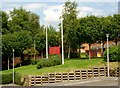
Birchgrove Church Tower
The Tower flagstaff, now missing, was used by the Ordnance Survey as a 3rd Order Triangulation Point (Intersected Station SN80/026).
Image: © Adrian Dust
Taken: 19 Apr 2011
0.24 miles
4
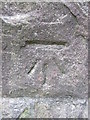
Ordnance Survey Cut Mark
This OS cut mark can be found on the NW angle of St John's Church. It marks a point 72.875m above mean sea level.
Image: © Adrian Dust
Taken: 20 Apr 2014
0.25 miles