IMAGES TAKEN NEAR TO
Lion Way, SWANSEA, SA7 9FY
Introduction
This page details the photographs taken nearby to Lion Way, SA7 9FY by members of the Geograph project.
The Geograph project started in 2005 with the aim of publishing, organising and preserving representative images for every square kilometre of Great Britain, Ireland and the Isle of Man.

There are currently over 7.5m images from over14,400 individuals and you can help contribute to the project by visiting https://www.geograph.org.uk
Image Map
Images are licensed for reuse under creativecommons.org/licenses/by-sa/2.0
Notes
- Clicking on the map will re-center to the selected point.
- The higher the marker number, the further away the image location is from the centre of the postcode.
Image Listing (5 Images Found)
Images are licensed for reuse under creativecommons.org/licenses/by-sa/2.0
Image
Details
Distance
1
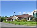
The Dylan Thomas restaurant
Part of the Hungry Horse chain
Image: © David Smith
Taken: 2 Jun 2018
0.18 miles
2
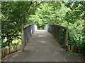
Bridge at the north end of Fendrod Lake, Llansamlet, Swansea
Image: © Ruth Sharville
Taken: 6 Jul 2010
0.18 miles
3
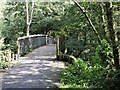
Footbridge over the Fendrod stream, Llansamlet, Swansea
Footbridge just north of the point where the stream joins Llyn y Fendrod (The Fendrod Lake).
Image: © David Lewis
Taken: 23 Sep 2022
0.20 miles
5
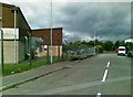
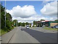
St David's Industrial Estate Access Road 2
Image: © Alex McGregor
Taken: 8 Jun 2011
0.23 miles