IMAGES TAKEN NEAR TO
Cefn Road, SWANSEA, SA7 9EZ
Introduction
This page details the photographs taken nearby to Cefn Road, SA7 9EZ by members of the Geograph project.
The Geograph project started in 2005 with the aim of publishing, organising and preserving representative images for every square kilometre of Great Britain, Ireland and the Isle of Man.

There are currently over 7.5m images from over14,400 individuals and you can help contribute to the project by visiting https://www.geograph.org.uk
Image Map
Images are licensed for reuse under creativecommons.org/licenses/by-sa/2.0
Notes
- Clicking on the map will re-center to the selected point.
- The higher the marker number, the further away the image location is from the centre of the postcode.
Image Listing (8 Images Found)
Images are licensed for reuse under creativecommons.org/licenses/by-sa/2.0
Image
Details
Distance
1

North end of closed Garth Road
Garth road has taken a beating from redevelopments. The new A4067 (bridge pictured in Image) isolated the north end of this road so it has been blocked off. It seems to be used mainly by dog walkers - hence the red bin - and presumably the farmer can still open the gate for access to fields.
Image: © Nigel Davies
Taken: 16 May 2009
0.09 miles
2
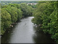
River Tawe, near Glais
Looking upstream, taken from the A4067 bridge.
Image: © Chris Eilbeck
Taken: 1 Jun 2008
0.16 miles
3

River and road
A4067 over the Tawe near Glais.
Image: © Alan Hughes
Taken: 7 Oct 2018
0.17 miles
4
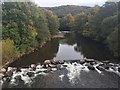
Tawe River
View of the Tawe from the bridge at Glais.
Image: © Alan Hughes
Taken: 7 Oct 2018
0.19 miles
6
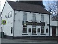
Globe Inn
The Globe Inn in the centre of Glais.
Image: © John Phoenix
Taken: 22 Mar 2007
0.24 miles
7
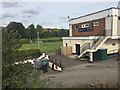
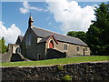
Golf Clubhouse
Mond Valley Golf Clubhouse.
Image: © Alan Hughes
Taken: 7 Oct 2018
0.24 miles
8
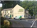
The Globe Inn
Public house in Glais on the corner of School Road.
Image: © Alan Hughes
Taken: 7 Oct 2018
0.24 miles