IMAGES TAKEN NEAR TO
Phoenix Way, SWANSEA, SA7 9EH
Introduction
This page details the photographs taken nearby to Phoenix Way, SA7 9EH by members of the Geograph project.
The Geograph project started in 2005 with the aim of publishing, organising and preserving representative images for every square kilometre of Great Britain, Ireland and the Isle of Man.

There are currently over 7.5m images from over14,400 individuals and you can help contribute to the project by visiting https://www.geograph.org.uk
Image Map
Images are licensed for reuse under creativecommons.org/licenses/by-sa/2.0
Notes
- Clicking on the map will re-center to the selected point.
- The higher the marker number, the further away the image location is from the centre of the postcode.
Image Listing (11 Images Found)
Images are licensed for reuse under creativecommons.org/licenses/by-sa/2.0
Image
Details
Distance
1
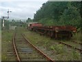
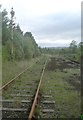
Swansea Vale Railway
The now disused and rapidly crumbling northern platform of the Swansea Vale Railway. Reversing siding now occupied by sundry carriages, also rusting and decaying.
As far as I can tell, there was never a station here when the Swansea to Brecon line was active - this is a more recent addition and indeed is much shorter than a conventional railway platform and would have at most served two carriages.
Image: © Hywel Williams
Taken: 26 May 2008
0.11 miles
2
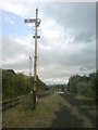
Signal on the Swansea Vale Railway
A rather sad and neglected looking signal on the Swansea Vale Railway.
On a cursory look, this looks fine but a more detailed examination reveals that this signal has been the subject of weather damage and vandalism over the many years it has stood here. It was the most complete example of a signal found on the line however - the others were either missing or had suffered far worse over the intervening years.
Even as part of the heritage service, the signal served little use as in latter use, the short stretch beyond the station area was only used as a reversing siding to allow locomotives to be reversed and relocated to the front of carriages about to move in the opposite direction down the line.
In the distance is the northern station that was used as a terminus for the heritage line that used this railway until a couple of years ago - now threatened with closure by the local council in favour of redevelopment into industrial and residential use.
Image: © Hywel Williams
Taken: 26 May 2008
0.12 miles
3
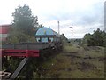
The end of the line
Not just the end of the line for this short stretch of heritage line - but possibly the end of the entire history of the Swansea to Brecon line - this being the last remaining vestige. Major costs as well as changing land property prices in the surrounding area has recently meant that Swansea council has decided to redevelop the area and refused to renew the lease on the railway.
This poignant scene could soon be a factory or a retail outlet.
It would still be a shame to lose this part of our history in favour of some short term land redevelopment.
Image: © Hywel Williams
Taken: 26 May 2008
0.12 miles
4
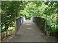
Bridge at the north end of Fendrod Lake, Llansamlet, Swansea
Image: © Ruth Sharville
Taken: 6 Jul 2010
0.14 miles
5
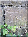
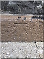
Ordnance Survey Cut Mark
This OS cut mark can be found on the wall on the SW side of the road. It marks a point 15.661m above mean sea level.
Image: © Adrian Dust
Taken: 1 Sep 2015
0.15 miles
6
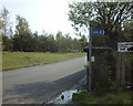
Former entrance to the Swansea Vale Railway on Jersey Road, Swansea
This 1998 view shows the former entrance to the preserved line run by the Swansea Vale Railway Society. The incline used to lead to the SVR's Six Pit Station. A double track viaduct used to continue from an abutment on the right hand side and continue across the road towards Llansamlet.
This line originally opened as part of the Swansea Vale Railway in the 1870s. It was taken over by the Midland Railway in 1876 and additional through routes were added as a result. Passenger services ceased in 1950 and complete closure took place in the 1960s. By 1985 the only railway here was the section preserved by the SVR Society. In 2007, Swansea Council decided to redevelop the area and by 2010 the preserved railway was itself history, although the society itself lives on.
Image: © vectorkraft
Taken: 8 May 1998
0.16 miles
7
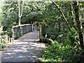
Footbridge over the Fendrod stream, Llansamlet, Swansea
Footbridge just north of the point where the stream joins Llyn y Fendrod (The Fendrod Lake).
Image: © David Lewis
Taken: 23 Sep 2022
0.16 miles
8
Decayed signal
A badly corroded signal on the Swansea Vale Railway. The semaphore arm of the signal seems to have disappeared and the rest of the post and signalling equipment also seems to have decayed over the years.
Image: © Hywel Williams
Taken: 26 May 2008
0.19 miles
9
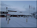
Ramada Jarvis Hotel, Llansamlet, Swansea
Image: © Ruth Sharville
Taken: 17 Dec 2010
0.22 miles
10
Ordnance Survey Cut Mark
This OS cut mark can be found on the front of the Colliers Arms. It marks a point 35.522m above mean sea level.
Image: © Adrian Dust
Taken: 1 Sep 2015
0.24 miles