IMAGES TAKEN NEAR TO
Felin Fran, SWANSEA, SA7 9DW
Introduction
This page details the photographs taken nearby to Felin Fran, SA7 9DW by members of the Geograph project.
The Geograph project started in 2005 with the aim of publishing, organising and preserving representative images for every square kilometre of Great Britain, Ireland and the Isle of Man.

There are currently over 7.5m images from over14,400 individuals and you can help contribute to the project by visiting https://www.geograph.org.uk
Image Map
Images are licensed for reuse under creativecommons.org/licenses/by-sa/2.0
Notes
- Clicking on the map will re-center to the selected point.
- The higher the marker number, the further away the image location is from the centre of the postcode.
Image Listing (18 Images Found)
Images are licensed for reuse under creativecommons.org/licenses/by-sa/2.0
Image
Details
Distance
1
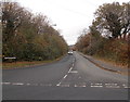
Ynysallan Road, Swansea
The route of Ynysallan Road ahead is parallel with the M4 motorway, separated from it by the narrow band of vegetation on the left.
This junction is the point where Walters Road on the left is renamed Heol-las on the right.
Image: © Jaggery
Taken: 28 Nov 2013
0.04 miles
2
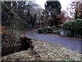
Bridge over Nant-bran in Swansea
Viewed from Walters Road. Nant-bran http://www.geograph.org.uk/photo/3807796 is a small stream.
Image: © Jaggery
Taken: 28 Nov 2013
0.05 miles
3
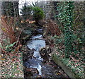
Nant Bran flows towards a railway bridge in Swansea
Viewed from this http://www.geograph.org.uk/photo/3807783 bridge looking towards this http://www.geograph.org.uk/photo/3804860 railway bridge.
Image: © Jaggery
Taken: 28 Nov 2013
0.06 miles
4
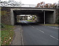
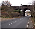
Under a motorway bridge towards Felin Fran railway bridge, Swansea
Looking under the M4 motorway towards this http://www.geograph.org.uk/photo/3804860 bridge.
Image: © Jaggery
Taken: 28 Nov 2013
0.07 miles
5
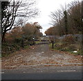
Access road to the railway near Felin Fran bridge, Swansea
Viewed from the western side of this http://www.geograph.org.uk/photo/3804860 bridge. A sturdy black metal barrier and metal gates and fences prevent unauthorised railway access.
Image: © Jaggery
Taken: 28 Nov 2013
0.07 miles
6
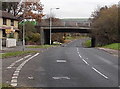
Walters Road motorway bridge, Swansea
The bridge carries the M4 motorway over Walters Road.
A few metres beyond the far side of the bridge, Walters Road is renamed Heol Las.
Image: © Jaggery
Taken: 28 Nov 2013
0.07 miles
7
Railway Bridge, near Heol Las, Llansamlet
Image: © David Lewis
Taken: 25 Nov 2013
0.07 miles
8
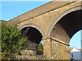
Felin Fran railway bridge, Swansea
Viewed along Walters Road. The railway on the bridge is part of the Swansea District Line, which is mainly used for freight. It is occasionally used for passenger services such as when engineering work makes the usual route unavailable.
Image: © Jaggery
Taken: 28 Nov 2013
0.07 miles
9
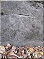
Ordnance Survey Cut Mark
This OS cut mark can be found on the SE buttress of the railway bridge. It marks a point 14.265m above mean sea level.
Image: © Adrian Dust
Taken: 2 Sep 2015
0.08 miles
10
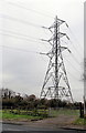
Electricity pylon on the south side of Walters Road, Swansea
Located in a field, the pylon is about 50 metres from the road.
Image: © Jaggery
Taken: 28 Nov 2013
0.09 miles